Collepasso night lights from space
Night Light of Collepasso (Apulia) from space (Italy) Src. Average luminocity for 10x10km area is 38.8929% and for 50x50km: 28.3679%.
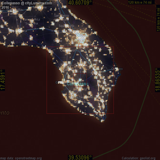
Analysis of Collepasso night lights 2016
Square area 10x10 km:
100  4.71%
4.71%
90-99 5.52%
80-89 6.82%
70-79 4.06%
60-69 5.03%
50-59 3.41%
40-49 3.08%
30-39 7.14%
20-29 26.14%
10-19 30.36%
0-9 3.73%
4.71%90-99
5.52%80-89
6.82%70-79
4.06%60-69
5.03%50-59
3.41%40-49
3.08%30-39
7.14%20-29
26.14%10-19
30.36%0-9
3.73%Square area 50x50 km:
100 2.58%
90-99 5.22%
80-89 3.68%
70-79 3.23%
60-69 3.58%
50-59 2.48%
40-49 2.82%
30-39 5.93%
20-29 18.11%
10-19 22.15%
0-9 30.21%
2.58%90-99
5.22%80-89
3.68%70-79
3.23%60-69
3.58%50-59
2.48%40-49
2.82%30-39
5.93%20-29
18.11%10-19
22.15%0-9
30.21%Clear (daylight) street map image can be seen on geolist.org.
Map coordinates:
40° 36' 25.5" North, 17° 27' 32.8" East
40° 4' 16.1" North, 18° 9' 44" East
39° 31' 51.5" North, 18° 51' 55.3" East
Some cities around Collepasso sort by population:
• Casarano
6.7 km =4.2 mi,  179°
179°
• Matino
5 km =3.1 mi,  206°
206°
• Aradeo
7 km =4.3 mi,  336°
336°
• Parabita
3.7 km =2.3 mi,  234°
234°
• Cutrofiano
7 km =4.3 mi,  29°
29°
• Alezio
9 km =5.6 mi,  263°
263°
• Neviano
5.6 km =3.5 mi,  314°
314°
• Tuglie
5.4 km =3.4 mi,  272°
272°
3178360 (p: 6,178)
Sources (retrieved 2019-11-25):
» Earth at Night: Flat Maps 2012, 2016