Aradeo night lights from space
Night Light of Aradeo (Apulia) from space (Italy) Src. Average luminocity for 10x10km area is 41.1721% and for 50x50km: 30.2365%.
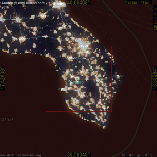
Analysis of Aradeo night lights 2016
Square area 10x10 km:
100  4.87%
4.87%
90-99 6.33%
80-89 2.76%
70-79 3.57%
60-69 5.68%
50-59 3.9%
40-49 6.17%
30-39 12.82%
20-29 45.78%
10-19 8.12%
0-9 0%
4.87%90-99
6.33%80-89
2.76%70-79
3.57%60-69
5.68%50-59
3.9%40-49
6.17%30-39
12.82%20-29
45.78%10-19
8.12%0-9
0%Square area 50x50 km:
100 3.01%
90-99 5.8%
80-89 3.78%
70-79 3.56%
60-69 4%
50-59 2.82%
40-49 3.23%
30-39 6.12%
20-29 18.51%
10-19 20.36%
0-9 28.82%
3.01%90-99
5.8%80-89
3.78%70-79
3.56%60-69
4%50-59
2.82%40-49
3.23%30-39
6.12%20-29
18.51%10-19
20.36%0-9
28.82%Clear (daylight) street map image can be seen on geolist.org.
Map coordinates:
40° 39' 52.9" North, 17° 25' 35" East
40° 7' 45.2" North, 18° 7' 46.2" East
39° 35' 22.1" North, 18° 49' 57.5" East
Some cities around Aradeo sort by population:
• Galatina
6.1 km =3.8 mi,  34°
34°
• Galatone
5.5 km =3.4 mi,  290°
290°
• Parabita
8.7 km =5.4 mi,  181°
181°
• Cutrofiano
6.2 km =3.9 mi,  93°
93°
• Collepasso
7 km =4.3 mi,  156°
156°
• Neviano
2.8 km =1.7 mi,  205°
205°
• Tuglie
6.7 km =4.2 mi,  202°
202°
• Soleto
9.2 km =5.7 mi,  45°
45°
3182935 (p: 9,570)
Sources (retrieved 2019-11-25):
» Earth at Night: Flat Maps 2012, 2016