Fossombrone night lights from space
Night Light of Fossombrone (The Marches) from space (Italy) Src. Average luminocity for 10x10km area is 8.4% and for 50x50km: 12.3267%.
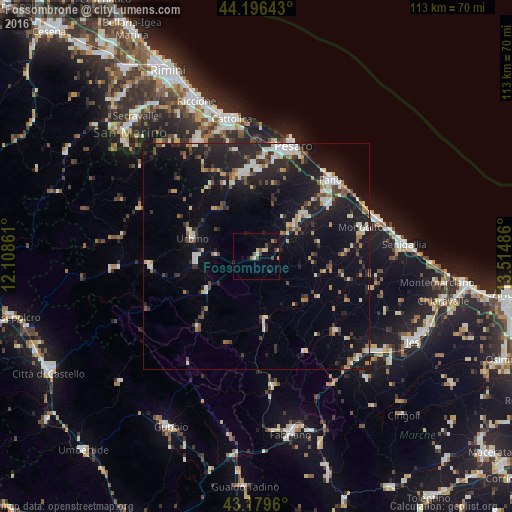
Analysis of Fossombrone night lights 2016
Square area 10x10 km:
 0.15%
0.15%90-99
1.52%80-89
1.36%70-79
0.45%60-69
0.91%50-59
1.67%40-49
1.21%30-39
2.42%20-29
1.21%10-19
1.67%0-9
87.42%Square area 50x50 km:
1.28%90-99
2.26%80-89
1.1%70-79
1.06%60-69
1.28%50-59
1.38%40-49
1.42%30-39
1.73%20-29
4.33%10-19
12.15%0-9
72.01%Clear (daylight) street map image can be seen on geolist.org.
Map coordinates:
44° 11' 47.1" North, 12° 6' 31" East
43° 41' 24.6" North, 12° 48' 42.2" East
43° 10' 46.6" North, 13° 30' 53.5" East
Some cities around Fossombrone sort by population:
• Fano
23.5 km =14.6 mi,  44°
44°
• Fermignano
12.7 km =7.9 mi,  271°
271°
• Lucrezia
13.8 km =8.6 mi,  48°
48°
• Marotta
25.7 km =16 mi,  61°
61°
• Urbino
14.7 km =9.1 mi,  285°
285°
• Urbania
23.5 km =14.6 mi,  264°
264°
• Calcinelli
11.2 km =7 mi, 50°
• Cagli
20.4 km =12.7 mi,  219°
219°
3176630 (p: 6,808)
Sources (retrieved 2019-11-25):
» Earth at Night: Flat Maps 2012, 2016