Calcinelli night lights from space
Night Light of Calcinelli (The Marches) from space (Italy) Src. Average luminocity for 10x10km area is 23.503% and for 50x50km: 16.042%.
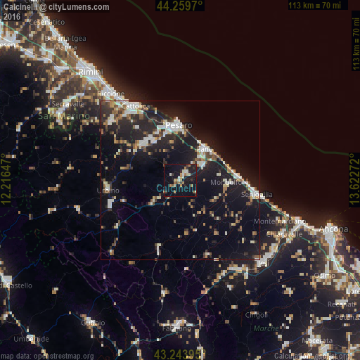
Analysis of Calcinelli night lights 2016
Square area 10x10 km:
 0.45%
0.45%90-99
4.39%80-89
3.33%70-79
3.03%60-69
4.85%50-59
1.52%40-49
1.52%30-39
3.03%20-29
5%10-19
34.39%0-9
38.48%Square area 50x50 km:
2.02%90-99
3.17%80-89
1.31%70-79
1.19%60-69
1.69%50-59
1.78%40-49
1.94%30-39
2.2%20-29
5.73%10-19
15.81%0-9
63.15%Clear (daylight) street map image can be seen on geolist.org.
Map coordinates:
44° 15' 34.9" North, 12° 12' 59.3" East
43° 45' 14.3" North, 12° 55' 10.5" East
43° 14' 38.2" North, 13° 37' 21.8" East
Some cities around Calcinelli sort by population:
• Pesaro
17.3 km =10.7 mi,  359°
359°
• Fano
12.4 km =7.7 mi,  38°
38°
• Fermignano
22.4 km =13.9 mi,  252°
252°
• Fossombrone
11.2 km =7 mi,  230°
230°
• Marotta
18.4 km =11.4 mi,  86°
86°
• Lucrezia
2.7 km =1.7 mi, 37°
• Marotta
14.9 km =9.3 mi,  70°
70°
• Urbino
23 km =14.3 mi,  262°
262°
3181222 (p: 5,198)
Sources (retrieved 2019-11-25):
» Earth at Night: Flat Maps 2012, 2016