Urbino night lights from space
Night Light of Urbino (The Marches) from space (Italy) Src. Average luminocity for 10x10km area is 16.3197% and for 50x50km: 11.6338%.
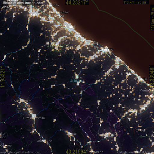
Analysis of Urbino night lights 2016
Square area 10x10 km:
 1.97%
1.97%90-99
3.94%80-89
1.67%70-79
0%60-69
0.91%50-59
2.73%40-49
1.36%30-39
3.33%20-29
2.42%10-19
10.45%0-9
71.21%Square area 50x50 km:
1.24%90-99
2.12%80-89
1.02%70-79
0.89%60-69
1.09%50-59
1.43%40-49
1.89%30-39
1.83%20-29
5.35%10-19
9.54%0-9
73.6%Clear (daylight) street map image can be seen on geolist.org.
Map coordinates:
44° 13' 55.8" North, 11° 55' 59.6" East
43° 43' 34.4" North, 12° 38' 10.8" East
43° 12' 57.4" North, 13° 20' 22.1" East
Some cities around Urbino sort by population:
• Fermignano
4 km =2.5 mi,  158°
158°
• Fossombrone
14.7 km =9.1 mi,  105°
105°
• Morciano di Romagna
21 km =13 mi,  3°
3°
• Urbania
11.3 km =7 mi,  235°
235°
• San Giovanni in Marignano
24.5 km =15.2 mi,  14°
14°
• Calcinelli
23 km =14.3 mi,  82°
82°
• Cagli
19.9 km =12.4 mi,  176°
176°
• Monte Giardino, SM
23.8 km =14.8 mi,  328°
328°
3165035 (p: 5,858)
Sources (retrieved 2019-11-25):
» Earth at Night: Flat Maps 2012, 2016