Fano night lights from space
Night Light of Fano (The Marches) from space (Italy) Src. Average luminocity for 10x10km area is 36.9175% and for 50x50km: 12.8983%.
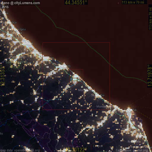
Analysis of Fano night lights 2016
Square area 10x10 km:
 6.98%
6.98%90-99
9.84%80-89
0.95%70-79
0.63%60-69
7.62%50-59
4.29%40-49
4.44%30-39
4.6%20-29
8.1%10-19
41.43%0-9
11.11%Square area 50x50 km:
1.73%90-99
2.52%80-89
1%70-79
0.88%60-69
1.32%50-59
1.27%40-49
1.51%30-39
1.52%20-29
4.81%10-19
15.16%0-9
68.27%Clear (daylight) street map image can be seen on geolist.org.
Map coordinates:
44° 20' 43.8" North, 12° 18' 48.7" East
43° 50' 25.9" North, 13° 0' 59.9" East
43° 19' 52.4" North, 13° 43' 11.2" East
Some cities around Fano sort by population:
• Pesaro
11.1 km =6.9 mi,  313°
313°
• Senigallia
20.7 km =12.9 mi,  131°
131°
• Cattolica
26.2 km =16.3 mi,  300°
300°
• Fossombrone
23.5 km =14.6 mi,  224°
224°
• Marotta
13.5 km =8.4 mi, 128°
• Lucrezia
9.7 km =6 mi, 219°
• Marotta
7.8 km =4.8 mi, 126°
• Calcinelli
12.4 km =7.7 mi, 218°
3177219 (p: 38,999)
Sources (retrieved 2019-11-25):
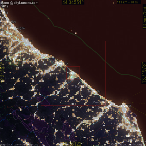
» Earth at Night: Flat Maps 2012, 2016