Roncadelle night lights from space
Night Light of Roncadelle (Lombardy) from space (Italy) Src. Average luminocity for 10x10km area is 83.8985% and for 50x50km: 40.2195%.
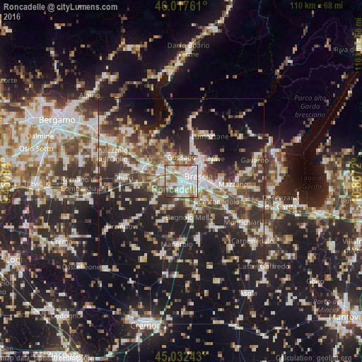
Analysis of Roncadelle night lights 2016
Square area 10x10 km:
 31.52%
90-99
26.52%80-89
4.39%70-79
8.79%60-69
16.06%50-59
6.21%40-49
2.73%30-39
3.79%20-29
0%10-19
0%0-9
0%Square area 50x50 km:
6.78%90-99
7.91%80-89
3.46%70-79
3.85%60-69
5.3%50-59
6.8%40-49
6.39%30-39
8.28%20-29
13.74%10-19
21.6%0-9
15.89%Clear (daylight) street map image can be seen on geolist.org.
Map coordinates:
46° 1' 3.4" North, 9° 27' 3.4" East
45° 31' 37.8" North, 10° 9' 14.7" East
45° 1' 56.7" North, 10° 51' 25.9" East
Some cities around Roncadelle sort by population:
• Brescia
4.8 km =3 mi,  78°
78°
• Gussago
6.3 km =3.9 mi,  2°
2°
• Piazza
6.7 km =4.2 mi, 0°
• Travagliato
5.8 km =3.6 mi,  266°
266°
• Castel Mella
3.2 km =2 mi,  192°
192°
• Castegnato
4.9 km =3 mi,  320°
320°
• Flero
5.3 km =3.3 mi,  160°
160°
• Torbole Casaglia
3.3 km =2.1 mi,  241°
241°
6535203 (p: 8,892)
Sources (retrieved 2019-11-25):
» Earth at Night: Flat Maps 2012, 2016