Travagliato night lights from space
Night Light of Travagliato (Lombardy) from space (Italy) Src. Average luminocity for 10x10km area is 68.4894% and for 50x50km: 40.9113%.
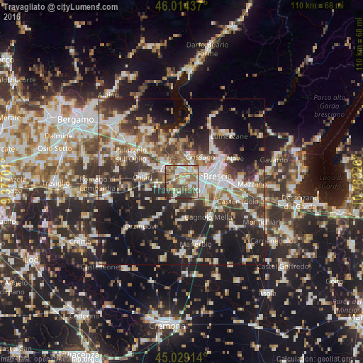
Analysis of Travagliato night lights 2016
Square area 10x10 km:
 12.73%
90-99
15.61%80-89
8.64%70-79
7.88%60-69
16.21%50-59
15.45%40-49
9.39%30-39
11.21%20-29
2.88%10-19
0%0-9
0%Square area 50x50 km:
7.12%90-99
8.26%80-89
3.65%70-79
3.72%60-69
5.54%50-59
6.73%40-49
6.43%30-39
7.77%20-29
12.91%10-19
22.61%0-9
15.25%Clear (daylight) street map image can be seen on geolist.org.
Map coordinates:
46° 0' 51.7" North, 9° 22' 37.2" East
45° 31' 26.1" North, 10° 4' 48.5" East
45° 1' 44.9" North, 10° 46' 59.7" East
Some cities around Travagliato sort by population:
• Ospitaletto
3.2 km =2 mi,  353°
353°
• Rovato
7.5 km =4.7 mi,  305°
305°
• Castel Mella
5.8 km =3.6 mi,  118°
118°
• Roncadelle
5.8 km =3.6 mi,  86°
86°
• Castegnato
4.9 km =3 mi,  32°
32°
• Castrezzato
7.9 km =4.9 mi,  259°
259°
• Torbole Casaglia
3.1 km =1.9 mi,  113°
113°
• Trenzano
7.5 km =4.7 mi,  226°
226°
3165301 (p: 12,828)
Sources (retrieved 2019-11-25):
» Earth at Night: Flat Maps 2012, 2016