Fossò night lights from space
Night Light of Fossò (Veneto) from space (Italy) Src. Average luminocity for 10x10km area is 65.6619% and for 50x50km: 47.499%.
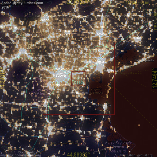
Analysis of Fossò night lights 2016
Square area 10x10 km:
100  6.98%
6.98%
90-99 15.08%
80-89 6.67%
70-79 10.16%
60-69 16.03%
50-59 17.14%
40-49 18.73%
30-39 6.19%
20-29 2.7%
10-19 0.32%
0-9 0%
6.98%90-99
15.08%80-89
6.67%70-79
10.16%60-69
16.03%50-59
17.14%40-49
18.73%30-39
6.19%20-29
2.7%10-19
0.32%0-9
0%Square area 50x50 km:
100 8.61%
90-99 9.62%
80-89 4.36%
70-79 5.65%
60-69 8.15%
50-59 9.5%
40-49 9.15%
30-39 7.65%
20-29 10.25%
10-19 10.41%
0-9 16.65%
8.61%90-99
9.62%80-89
4.36%70-79
5.65%60-69
8.15%50-59
9.5%40-49
9.15%30-39
7.65%20-29
10.25%10-19
10.41%0-9
16.65%Clear (daylight) street map image can be seen on geolist.org.
Map coordinates:
45° 52' 38.9" North, 11° 20' 35.3" East
45° 23' 8.9" North, 12° 2' 46.6" East
44° 53' 23.4" North, 12° 44' 57.8" East
Some cities around Fossò sort by population:
• Vigonza
7.8 km =4.8 mi,  314°
314°
• Camponogara
3.2 km =2 mi,  102°
102°
• Dolo
5.3 km =3.3 mi,  34°
34°
• Fiesso
3.9 km =2.4 mi,  345°
345°
• Legnaro
8 km =5 mi,  232°
232°
• Stra
3.8 km =2.4 mi,  318°
318°
• Villatora
6.2 km =3.9 mi,  271°
271°
• Fiesso d'Artico
4.2 km =2.6 mi,  341°
341°
3218993 (p: 5,021)
Sources (retrieved 2019-11-25):
» Earth at Night: Flat Maps 2012, 2016