Cattolica night lights from space
Night Light of Cattolica (Emilia-Romagna) from space (Italy) Src. Average luminocity for 10x10km area is 49.0714% and for 50x50km: 20.468%.
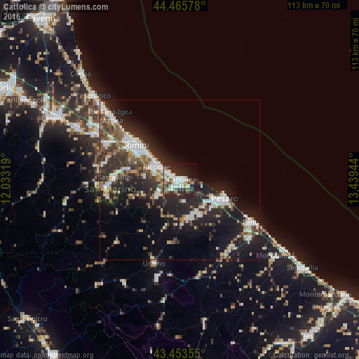
Analysis of Cattolica night lights 2016
Square area 10x10 km:
 11.43%
90-99
13.33%80-89
3.17%70-79
1.9%60-69
6.67%50-59
6.67%40-49
4.76%30-39
6.35%20-29
20.95%10-19
18.41%0-9
6.35%Square area 50x50 km:
3.51%90-99
4.41%80-89
1.24%70-79
1.36%60-69
2.12%50-59
2.84%40-49
3.19%30-39
3.53%20-29
9.14%10-19
13.76%0-9
54.88%Clear (daylight) street map image can be seen on geolist.org.
Map coordinates:
44° 27' 56.8" North, 12° 1' 59.5" East
43° 57' 42.6" North, 12° 44' 10.7" East
43° 27' 12.8" North, 13° 26' 22" East
Some cities around Cattolica sort by population:
• Rimini
17.3 km =10.7 mi,  307°
307°
• Pesaro
15.6 km =9.7 mi,  112°
112°
• Riccione
7.6 km =4.7 mi,  303°
303°
• Rivazzurra
13.5 km =8.4 mi, 311°
• Serravalle, SM
20.4 km =12.7 mi,  272°
272°
• Morciano di Romagna
8.6 km =5.3 mi,  232°
232°
• San Giovanni in Marignano
3.1 km =1.9 mi,  218°
218°
• Faetano, SM
19.4 km =12.1 mi,  258°
258°
3179347 (p: 16,189)
Sources (retrieved 2019-11-25):
» Earth at Night: Flat Maps 2012, 2016