Colorno night lights from space
Night Light of Colorno (Emilia-Romagna) from space (Italy) Src. Average luminocity for 10x10km area is 33.6365% and for 50x50km: 28.6141%.
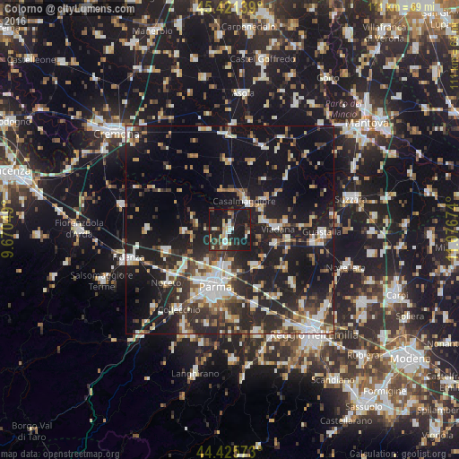
Analysis of Colorno night lights 2016
Square area 10x10 km:
 3.81%
3.81%90-99
6.98%80-89
4.92%70-79
2.38%60-69
0.79%50-59
3.65%40-49
4.29%30-39
6.19%20-29
13.81%10-19
51.27%0-9
1.9%Square area 50x50 km:
4.03%90-99
5.6%80-89
2.45%70-79
2.77%60-69
3.13%50-59
3.02%40-49
3.55%30-39
5.29%20-29
11.18%10-19
26.78%0-9
32.21%Clear (daylight) street map image can be seen on geolist.org.
Map coordinates:
45° 25' 17" North, 9° 40' 13.8" East
44° 55' 32.6" North, 10° 22' 25" East
44° 25' 32.6" North, 11° 4' 36.3" East
Some cities around Colorno sort by population:
• Parma
14.5 km =9 mi,  194°
194°
• Viadana
11.5 km =7.1 mi,  84°
84°
• Casalmaggiore
8 km =5 mi,  27°
27°
• Sant'Ilario d'Enza
19.4 km =12.1 mi,  162°
162°
• Noceto
20.2 km =12.6 mi,  230°
230°
• Castelnovo di Sotto
19.8 km =12.3 mi,  129°
129°
• Sorbolo
10.5 km =6.5 mi,  148°
148°
• Boretto
14.3 km =8.9 mi,  100°
100°
3178263 (p: 7,106)
Sources (retrieved 2019-11-25):
» Earth at Night: Flat Maps 2012, 2016