Noceto night lights from space
Night Light of Noceto (Emilia-Romagna) from space (Italy) Src. Average luminocity for 10x10km area is 36.4603% and for 50x50km: 23.9683%.
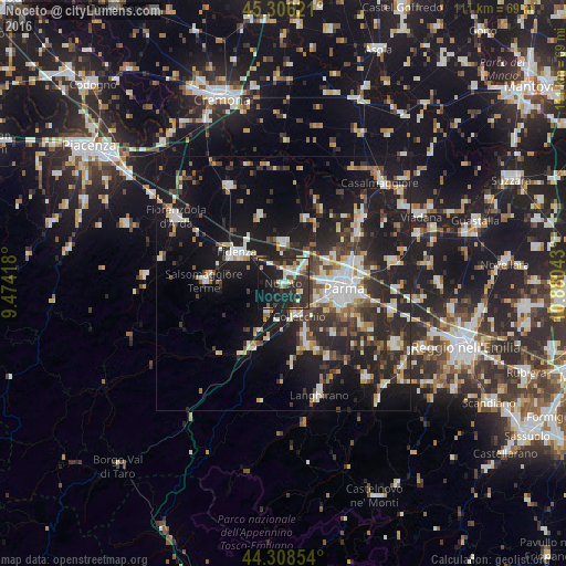
Analysis of Noceto night lights 2016
Square area 10x10 km:
 5.87%
5.87%90-99
6.19%80-89
3.65%70-79
2.22%60-69
3.49%50-59
3.17%40-49
3.65%30-39
10.48%20-29
24.44%10-19
29.52%0-9
7.3%Square area 50x50 km:
3.34%90-99
4.77%80-89
2.12%70-79
2.3%60-69
2.33%50-59
2.43%40-49
3.04%30-39
4.76%20-29
9.34%10-19
21.99%0-9
43.59%Clear (daylight) street map image can be seen on geolist.org.
Map coordinates:
45° 18' 22.4" North, 9° 28' 27" East
44° 48' 34.3" North, 10° 10' 38.3" East
44° 18' 30.7" North, 10° 52' 49.5" East
Some cities around Noceto sort by population:
• Parma
11.8 km =7.3 mi,  95°
95°
• Fidenza
11.2 km =7 mi,  304°
304°
• Salsomaggiore Terme
15.1 km =9.4 mi,  272°
272°
• Sant'Ilario d'Enza
22 km =13.7 mi, 104°
• Collecchio
7.1 km =4.4 mi,  154°
154°
• Sorbolo
21.4 km =13.3 mi,  79°
79°
• Colorno
20.2 km =12.6 mi,  50°
50°
• Langhirano
22.3 km =13.9 mi,  161°
161°
3172241 (p: 8,076)
Sources (retrieved 2019-11-25):
» Earth at Night: Flat Maps 2012, 2016