Cologne night lights from space
Night Light of Cologne (Lombardy) from space (Italy) Src. Average luminocity for 10x10km area is 63.2742% and for 50x50km: 45.78%.
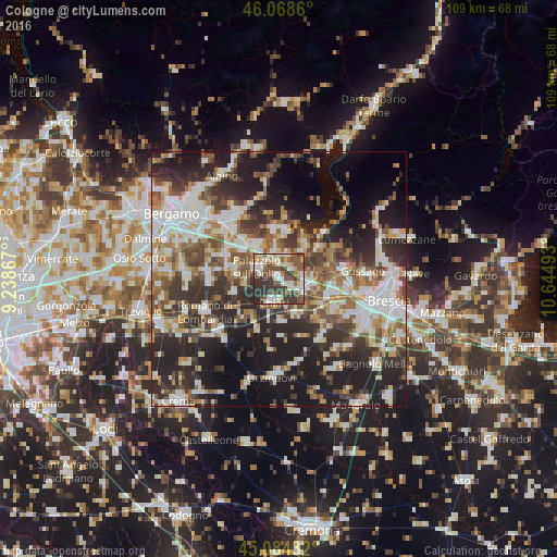
Analysis of Cologne night lights 2016
Square area 10x10 km:
 12.73%
90-99
13.94%80-89
8.64%70-79
5.45%60-69
5.3%50-59
16.67%40-49
11.52%30-39
17.58%20-29
8.18%10-19
0%0-9
0%Square area 50x50 km:
9.2%90-99
9.79%80-89
3.96%70-79
4.27%60-69
6.17%50-59
7.29%40-49
6.87%30-39
8.41%20-29
14.46%10-19
17.92%0-9
11.66%Clear (daylight) street map image can be seen on geolist.org.
Map coordinates:
46° 4' 7" North, 9° 14' 19.2" East
45° 34' 43" North, 9° 56' 30.5" East
45° 5' 3.6" North, 10° 38' 41.7" East
Some cities around Cologne sort by population:
• Palazzolo sull'Oglio
4.7 km =2.9 mi,  295°
295°
• Chiari
4.7 km =2.9 mi,  194°
194°
• Rovato
5 km =3.1 mi,  109°
109°
• Castelli Calepio
5.8 km =3.6 mi,  311°
311°
• Capriolo
6.1 km =3.8 mi,  352°
352°
• Coccaglio
2.9 km =1.8 mi,  124°
124°
• Corte Franca
6.8 km =4.2 mi,  32°
32°
• Adro
4.9 km =3 mi,  18°
18°
3178287 (p: 7,032)
Sources (retrieved 2019-11-25):
» Earth at Night: Flat Maps 2012, 2016