Rovato night lights from space
Night Light of Rovato (Lombardy) from space (Italy) Src. Average luminocity for 10x10km area is 65.097% and for 50x50km: 43.1096%.
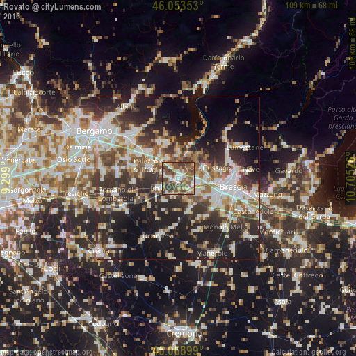
Analysis of Rovato night lights 2016
Square area 10x10 km:
100  10.45%
90-99 11.36%
80-89 9.55%
70-79 6.67%
60-69 10.3%
50-59 23.33%
40-49 15.45%
30-39 12.42%
20-29 0.45%
10-19 0%
0-9 0%
10.45%90-99
11.36%80-89
9.55%70-79
6.67%60-69
10.3%50-59
23.33%40-49
15.45%30-39
12.42%20-29
0.45%10-19
0%0-9
0%Square area 50x50 km:
100 8.35%
90-99 9.18%
80-89 3.76%
70-79 3.75%
60-69 5.53%
50-59 6.88%
40-49 6.68%
30-39 8.23%
20-29 13.81%
10-19 19.17%
0-9 14.67%
8.35%90-99
9.18%80-89
3.76%70-79
3.75%60-69
5.53%50-59
6.88%40-49
6.68%30-39
8.23%20-29
13.81%10-19
19.17%0-9
14.67%Clear (daylight) street map image can be seen on geolist.org.
Map coordinates:
46° 3' 12.7" North, 9° 17' 56.4" East
45° 33' 48.3" North, 10° 0' 7.7" East
45° 4' 8.4" North, 10° 42' 18.9" East
Some cities around Rovato sort by population:
• Chiari
6.5 km =4 mi,  243°
243°
• Ospitaletto
5.9 km =3.7 mi,  102°
102°
• Travagliato
7.5 km =4.7 mi,  125°
125°
• Coccaglio
2.3 km =1.4 mi,  271°
271°
• Cologne
5 km =3.1 mi,  289°
289°
• Castrezzato
6 km =3.7 mi,  195°
195°
• Adro
7.1 km =4.4 mi,  333°
333°
• Passirano
6.4 km =4 mi,  54°
54°
3168874 (p: 12,239)
Sources (retrieved 2019-11-25):
» Earth at Night: Flat Maps 2012, 2016