Corte Franca night lights from space
Night Light of Corte Franca (Lombardy) from space (Italy) Src. Average luminocity for 10x10km area is 61.5076% and for 50x50km: 42.222%.
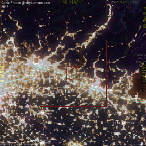
Analysis of Corte Franca night lights 2016
Square area 10x10 km:
 9.85%
9.85%90-99
11.06%80-89
8.94%70-79
7.42%60-69
8.18%50-59
17.42%40-49
13.64%30-39
15.15%20-29
5.76%10-19
2.58%0-9
0%Square area 50x50 km:
8.3%90-99
8.9%80-89
3.66%70-79
3.78%60-69
5.58%50-59
6.81%40-49
6.66%30-39
8.21%20-29
12.9%10-19
16.88%0-9
18.32%Clear (daylight) street map image can be seen on geolist.org.
Map coordinates:
46° 7' 10.2" North, 9° 17' 7.2" East
45° 37' 47.9" North, 9° 59' 18.5" East
45° 8' 10.1" North, 10° 41' 29.7" East
Some cities around Corte Franca sort by population:
• Capriolo
4.4 km =2.7 mi,  274°
274°
• Villongo
6.3 km =3.9 mi,  314°
314°
• Cologne
6.8 km =4.2 mi,  212°
212°
• Sarnico
5 km =3.1 mi,  335°
335°
• Provaglio d'Iseo
4.4 km =2.7 mi,  82°
82°
• Adro
2.3 km =1.4 mi,  243°
243°
• Passirano
7.3 km =4.5 mi,  120°
120°
• Iseo
5.8 km =3.6 mi,  56°
56°
3177983 (p: 6,282)
Sources (retrieved 2019-11-25):
» Earth at Night: Flat Maps 2012, 2016