Capriolo night lights from space
Night Light of Capriolo (Lombardy) from space (Italy) Src. Average luminocity for 10x10km area is 69.3091% and for 50x50km: 44.6401%.
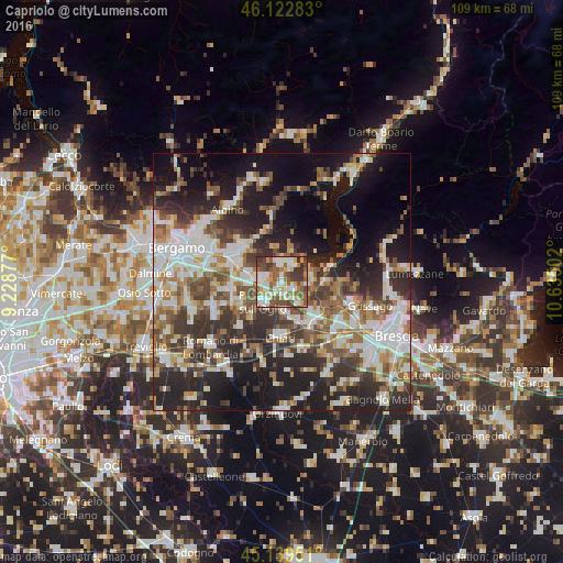
Analysis of Capriolo night lights 2016
Square area 10x10 km:
 14.09%
90-99
17.58%80-89
8.18%70-79
8.94%60-69
7.12%50-59
19.09%40-49
11.36%30-39
12.42%20-29
1.21%10-19
0%0-9
0%Square area 50x50 km:
9.02%90-99
9.49%80-89
3.95%70-79
4.29%60-69
6.22%50-59
7.12%40-49
6.59%30-39
7.94%20-29
13.37%10-19
16.8%0-9
15.21%Clear (daylight) street map image can be seen on geolist.org.
Map coordinates:
46° 7' 22.2" North, 9° 13' 43.6" East
45° 37' 60" North, 9° 55' 54.8" East
45° 8' 22.2" North, 10° 38' 6.1" East
Some cities around Capriolo sort by population:
• Palazzolo sull'Oglio
5.4 km =3.4 mi,  220°
220°
• Castelli Calepio
4.3 km =2.7 mi,  238°
238°
• Villongo
4 km =2.5 mi,  358°
358°
• Cologne
6.1 km =3.8 mi,  172°
172°
• Corte Franca
4.4 km =2.7 mi,  94°
94°
• Grumello del Monte
4.4 km =2.7 mi,  272°
272°
• Sarnico
4.8 km =3 mi,  28°
28°
• Adro
2.7 km =1.7 mi,  121°
121°
3180608 (p: 8,817)
Sources (retrieved 2019-11-25):
» Earth at Night: Flat Maps 2012, 2016