Coccaglio night lights from space
Night Light of Coccaglio (Lombardy) from space (Italy) Src. Average luminocity for 10x10km area is 64.5045% and for 50x50km: 44.4738%.
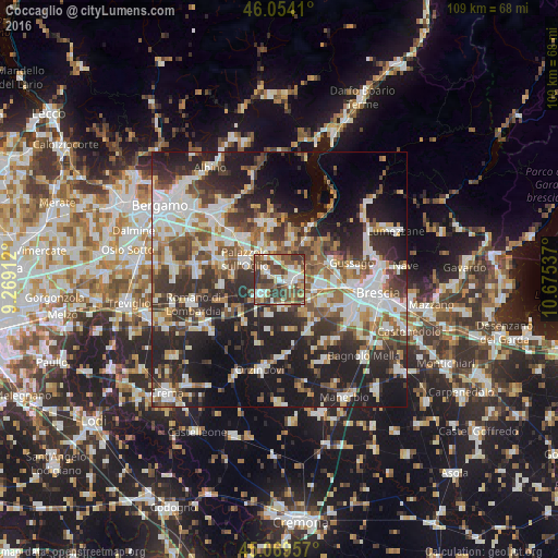
Analysis of Coccaglio night lights 2016
Square area 10x10 km:
 11.97%
90-99
12.42%80-89
9.7%70-79
5.15%60-69
6.82%50-59
19.09%40-49
16.67%30-39
17.27%20-29
0.91%10-19
0%0-9
0%Square area 50x50 km:
8.84%90-99
9.5%80-89
3.96%70-79
3.86%60-69
5.69%50-59
6.9%40-49
6.87%30-39
8.69%20-29
14.11%10-19
18.62%0-9
12.96%Clear (daylight) street map image can be seen on geolist.org.
Map coordinates:
46° 3' 14.8" North, 9° 16' 8.8" East
45° 33' 50.4" North, 9° 58' 20.1" East
45° 4' 10.5" North, 10° 40' 31.3" East
Some cities around Coccaglio sort by population:
• Palazzolo sull'Oglio
7.6 km =4.7 mi,  298°
298°
• Chiari
4.6 km =2.9 mi,  230°
230°
• Rovato
2.3 km =1.4 mi,  91°
91°
• Cologne
2.9 km =1.8 mi, 304°
• Castrezzato
5.9 km =3.7 mi,  173°
173°
• Corte Franca
7.4 km =4.6 mi,  9°
9°
• Castelcovati
7.2 km =4.5 mi,  196°
196°
• Adro
6.3 km =3.9 mi,  352°
352°
3178534 (p: 8,135)
Sources (retrieved 2019-11-25):
» Earth at Night: Flat Maps 2012, 2016