Chiari night lights from space
Night Light of Chiari (Lombardy) from space (Italy) Src. Average luminocity for 10x10km area is 50.753% and for 50x50km: 47.0187%.
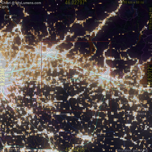
Analysis of Chiari night lights 2016
Square area 10x10 km:
 7.42%
7.42%90-99
9.09%80-89
6.67%70-79
1.97%60-69
5.3%50-59
9.7%40-49
10.45%30-39
21.82%20-29
26.21%10-19
1.36%0-9
0%Square area 50x50 km:
9.48%90-99
10.2%80-89
4.37%70-79
4.55%60-69
6.48%50-59
7.12%40-49
6.67%30-39
8.26%20-29
14.87%10-19
17.66%0-9
10.34%Clear (daylight) street map image can be seen on geolist.org.
Map coordinates:
46° 1' 40.7" North, 9° 13' 25.9" East
45° 32' 15.5" North, 9° 55' 37.2" East
45° 2' 34.7" North, 10° 37' 48.4" East
Some cities around Chiari sort by population:
• Palazzolo sull'Oglio
7.3 km =4.5 mi,  334°
334°
• Rovato
6.5 km =4 mi,  63°
63°
• Coccaglio
4.6 km =2.9 mi,  50°
50°
• Cologne
4.7 km =2.9 mi,  14°
14°
• Castrezzato
5.1 km =3.2 mi,  124°
124°
• Castelcovati
4.2 km =2.6 mi,  159°
159°
• Pontoglio
6.7 km =4.2 mi,  301°
301°
• Rudiano
6.2 km =3.9 mi,  210°
210°
3178850 (p: 15,541)
Sources (retrieved 2019-11-25):
» Earth at Night: Flat Maps 2012, 2016