Ceriano Laghetto night lights from space
Night Light of Ceriano Laghetto (Lombardy) from space (Italy) Src. Average luminocity for 10x10km area is 93.2727% and for 50x50km: 77.843%.
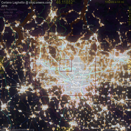
Analysis of Ceriano Laghetto night lights 2016
Square area 10x10 km:
 41.06%
90-99
30.61%80-89
14.39%70-79
12.73%60-69
0.91%50-59
0.3%40-49
0%30-39
0%20-29
0%10-19
0%0-9
0%Square area 50x50 km:
29.41%90-99
20.27%80-89
7.48%70-79
9.02%60-69
9.7%50-59
6.6%40-49
5.85%30-39
5.79%20-29
4.1%10-19
1.67%0-9
0.12%Clear (daylight) street map image can be seen on geolist.org.
Map coordinates:
46° 7' 7.8" North, 8° 22' 37.4" East
45° 37' 45.4" North, 9° 4' 48.6" East
45° 8' 7.5" North, 9° 46' 59.9" East
Some cities around Ceriano Laghetto sort by population:
• Saronno
3.5 km =2.2 mi,  262°
262°
• Caronno Pertusella
4.4 km =2.7 mi,  216°
216°
• Cesate
3.7 km =2.3 mi,  185°
185°
• Solaro
1.7 km =1.1 mi,  172°
172°
• Cogliate
1.9 km =1.2 mi,  356°
356°
• Lazzate
4.8 km =3 mi,  3°
3°
• Barlassina
4.8 km =3 mi,  52°
52°
• Rovello Porro
4.1 km =2.5 mi,  308°
308°
3179076 (p: 5,149)
Sources (retrieved 2019-11-25):
» Earth at Night: Flat Maps 2012, 2016