Castrocaro Terme e Terra del Sole night lights from space
Night Light of Castrocaro Terme e Terra del Sole (Emilia-Romagna) from space (Italy) Src. Average luminocity for 10x10km area is 16.1485% and for 50x50km: 16.5554%.
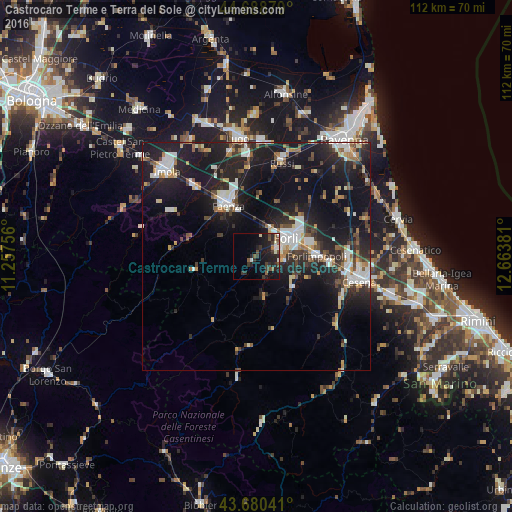
Analysis of Castrocaro Terme e Terra del Sole night lights 2016
Square area 10x10 km:
 0.91%
0.91%90-99
2.27%80-89
0.76%70-79
0%60-69
0.76%50-59
3.94%40-49
3.48%30-39
5.3%20-29
9.24%10-19
18.33%0-9
55%Square area 50x50 km:
2.7%90-99
2.96%80-89
1.08%70-79
1.4%60-69
1.65%50-59
1.83%40-49
2.37%30-39
2.28%20-29
6.83%10-19
17.16%0-9
59.75%Clear (daylight) street map image can be seen on geolist.org.
Map coordinates:
44° 41' 19.6" North, 11° 15' 27.2" East
44° 11' 12.3" North, 11° 57' 38.4" East
43° 40' 49.5" North, 12° 39' 49.7" East
Some cities around Castrocaro Terme e Terra del Sole sort by population:
• Forlì
7.5 km =4.7 mi,  58°
58°
• Cesena
23.1 km =14.4 mi,  103°
103°
• Faenza
13.2 km =8.2 mi,  330°
330°
• Forlimpopoli
13.4 km =8.3 mi,  87°
87°
• Bagnacavallo
25.3 km =15.7 mi,  3°
3°
• Castel Bolognese
19.6 km =12.2 mi,  318°
318°
• Meldola
10.4 km =6.5 mi,  128°
128°
• Russi
21.9 km =13.6 mi,  15°
15°
8224091 (p: 5,555)
Sources (retrieved 2019-11-25):
» Earth at Night: Flat Maps 2012, 2016