Bagnacavallo night lights from space
Night Light of Bagnacavallo (Emilia-Romagna) from space (Italy) Src. Average luminocity for 10x10km area is 37.1635% and for 50x50km: 21.8138%.
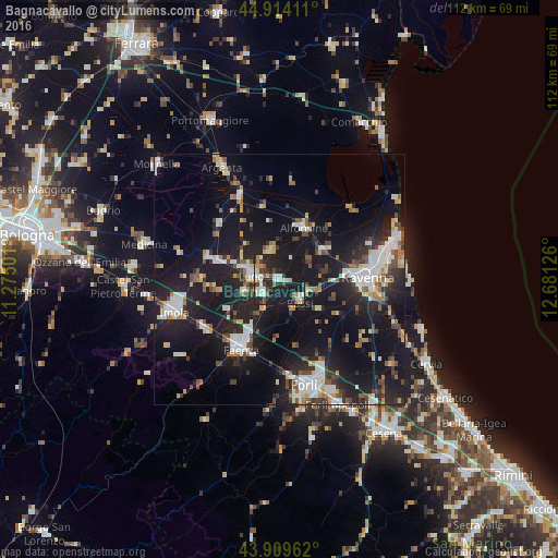
Analysis of Bagnacavallo night lights 2016
Square area 10x10 km:
 6.51%
6.51%90-99
8.41%80-89
3.17%70-79
1.43%60-69
4.13%50-59
4.6%40-49
3.02%30-39
5.08%20-29
18.1%10-19
44.92%0-9
0.63%Square area 50x50 km:
3.56%90-99
4.22%80-89
1.42%70-79
1.8%60-69
2.01%50-59
2.56%40-49
2.83%30-39
2.65%20-29
7.46%10-19
24.94%0-9
46.54%Clear (daylight) street map image can be seen on geolist.org.
Map coordinates:
44° 54' 50.8" North, 11° 16' 30" East
44° 24' 50.5" North, 11° 58' 41.3" East
43° 54' 34.6" North, 12° 40' 52.5" East
Some cities around Bagnacavallo sort by population:
• Ravenna
17.7 km =11 mi,  90°
90°
• Faenza
15.9 km =9.9 mi,  209°
209°
• Lugo
5.4 km =3.4 mi,  278°
278°
• Alfonsine
11.4 km =7.1 mi,  24°
24°
• Massa Lombarda
13 km =8.1 mi,  286°
286°
• Castel Bolognese
17.7 km =11 mi,  233°
233°
• Russi
6.1 km =3.8 mi,  133°
133°
• Fusignano
6.1 km =3.8 mi,  343°
343°
3182552 (p: 8,550)
Sources (retrieved 2019-11-25):
» Earth at Night: Flat Maps 2012, 2016