Botticino night lights from space
Night Light of Botticino (Lombardy) from space (Italy) Src. Average luminocity for 10x10km area is 59.503% and for 50x50km: 38.2711%.
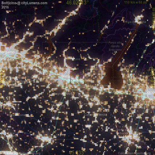
Analysis of Botticino night lights 2016
Square area 10x10 km:
 13.48%
90-99
14.85%80-89
4.55%70-79
5.45%60-69
6.36%50-59
10.76%40-49
10.61%30-39
11.67%20-29
16.06%10-19
6.21%0-9
0%Square area 50x50 km:
6.36%90-99
7.32%80-89
3.01%70-79
3.97%60-69
5.23%50-59
6.03%40-49
6.69%30-39
8.19%20-29
14.05%10-19
19.47%0-9
19.68%Clear (daylight) street map image can be seen on geolist.org.
Map coordinates:
46° 1' 12.5" North, 9° 36' 27.8" East
45° 31' 47" North, 10° 18' 39.1" East
45° 2' 6" North, 11° 0' 50.3" East
Some cities around Botticino sort by population:
• Brescia
7.5 km =4.7 mi,  274°
274°
• Rezzato
2.1 km =1.3 mi,  165°
165°
• Nave
6.6 km =4.1 mi,  338°
338°
• Borgosatollo
8 km =5 mi,  223°
223°
• Molinetto
5.4 km =3.4 mi,  136°
136°
• Castenedolo
6.3 km =3.9 mi,  193°
193°
• Bovezzo
8.6 km =5.3 mi,  321°
321°
• Prevalle
9 km =5.6 mi,  74°
74°
3181662 (p: 9,837)
Sources (retrieved 2019-11-25):
» Earth at Night: Flat Maps 2012, 2016