Rezzato night lights from space
Night Light of Rezzato (Lombardy) from space (Italy) Src. Average luminocity for 10x10km area is 67.0413% and for 50x50km: 38.7553%.
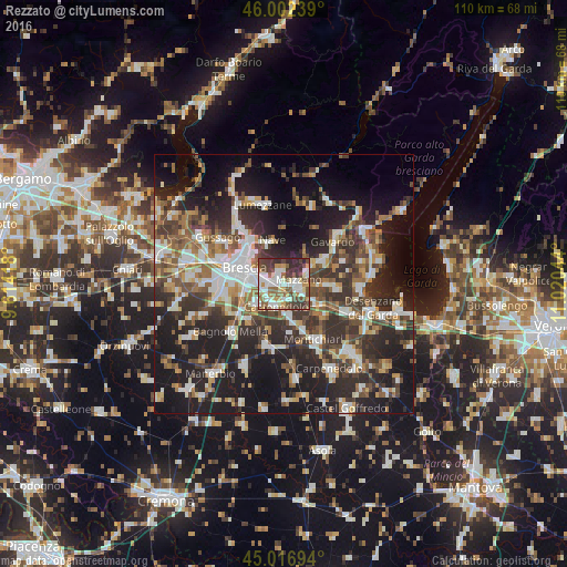
Analysis of Rezzato night lights 2016
Square area 10x10 km:
 15.56%
90-99
17.94%80-89
5.24%70-79
8.41%60-69
5.87%50-59
13.49%40-49
13.17%30-39
12.54%20-29
7.78%10-19
0%0-9
0%Square area 50x50 km:
6.39%90-99
7.4%80-89
3.02%70-79
4.03%60-69
5.3%50-59
5.9%40-49
6.56%30-39
8.19%20-29
14.18%10-19
22.45%0-9
16.59%Clear (daylight) street map image can be seen on geolist.org.
Map coordinates:
46° 0' 8.6" North, 9° 36' 51" East
45° 30' 42.6" North, 10° 19' 2.3" East
45° 1' 1" North, 11° 1' 13.6" East
Some cities around Rezzato sort by population:
• Brescia
8.4 km =5.2 mi,  288°
288°
• Nave
8.6 km =5.3 mi,  340°
340°
• Botticino
2.1 km =1.3 mi,  345°
345°
• Bedizzole
8.3 km =5.2 mi,  91°
91°
• Borgosatollo
7.1 km =4.4 mi,  237°
237°
• Piazza
8.3 km =5.2 mi, 91°
• Molinetto
3.8 km =2.4 mi,  121°
121°
• Castenedolo
4.6 km =2.9 mi,  205°
205°
3169452 (p: 12,779)
Sources (retrieved 2019-11-25):
» Earth at Night: Flat Maps 2012, 2016