Castelfranco Emilia night lights from space
Night Light of Castelfranco Emilia (Emilia-Romagna) from space (Italy) Src. Average luminocity for 10x10km area is 36.7939% and for 50x50km: 36.207%.
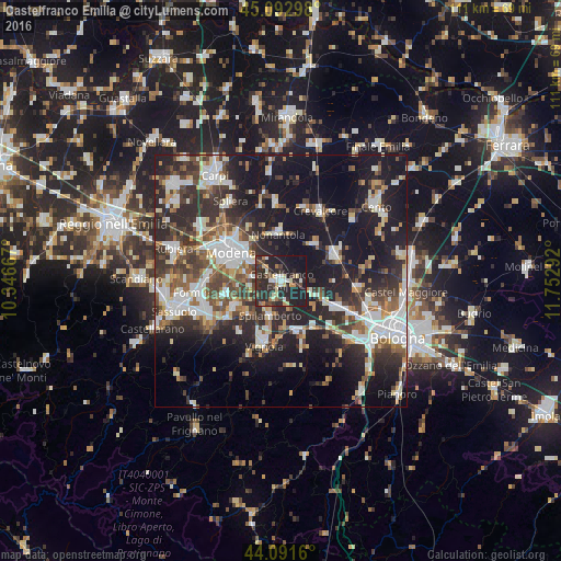
Analysis of Castelfranco Emilia night lights 2016
Square area 10x10 km:
 2.88%
2.88%90-99
5.45%80-89
6.21%70-79
3.18%60-69
3.18%50-59
3.18%40-49
4.85%30-39
8.64%20-29
33.94%10-19
26.97%0-9
1.52%Square area 50x50 km:
6.62%90-99
7.52%80-89
3.29%70-79
2.95%60-69
3.64%50-59
4.52%40-49
6.2%30-39
6.96%20-29
13.11%10-19
25.01%0-9
20.19%Clear (daylight) street map image can be seen on geolist.org.
Map coordinates:
45° 5' 34.7" North, 10° 20' 48" East
44° 35' 40" North, 11° 2' 59.2" East
44° 5' 29.8" North, 11° 45' 10.5" East
Some cities around Castelfranco Emilia sort by population:
• Modena
11.5 km =7.1 mi,  301°
301°
• Vignola
12.7 km =7.9 mi,  194°
194°
• San Giovanni in Persiceto
11.7 km =7.3 mi,  65°
65°
• Nonantola
9.3 km =5.8 mi,  354°
354°
• Anzola dell'Emilia
13.6 km =8.5 mi,  115°
115°
• Spilamberto
7.3 km =4.5 mi,  200°
200°
• Bazzano
10.7 km =6.6 mi,  164°
164°
• Sant'Agata Bolognese
9.8 km =6.1 mi,  41°
41°
3179686 (p: 17,315)
Sources (retrieved 2019-11-25):
» Earth at Night: Flat Maps 2012, 2016