Sant'Agata Bolognese night lights from space
Night Light of Sant'Agata Bolognese (Emilia-Romagna) from space (Italy) Src. Average luminocity for 10x10km area is 22.6333% and for 50x50km: 38.5323%.
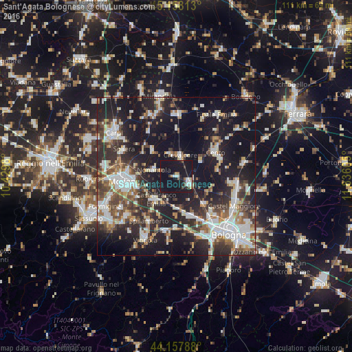
Analysis of Sant'Agata Bolognese night lights 2016
Square area 10x10 km:
 2.88%
2.88%90-99
3.79%80-89
1.21%70-79
1.21%60-69
1.06%50-59
1.36%40-49
3.18%30-39
2.12%20-29
4.24%10-19
67.42%0-9
11.52%Square area 50x50 km:
7.18%90-99
8.09%80-89
3.61%70-79
2.95%60-69
3.86%50-59
4.66%40-49
5.96%30-39
6.71%20-29
13.54%10-19
30.28%0-9
13.16%Clear (daylight) street map image can be seen on geolist.org.
Map coordinates:
45° 9' 29.3" North, 10° 25' 47.3" East
44° 39' 36.6" North, 11° 7' 58.5" East
44° 9' 28.4" North, 11° 50' 9.8" East
Some cities around Sant'Agata Bolognese sort by population:
• Cento
14.5 km =9 mi,  57°
57°
• Castelfranco Emilia
9.8 km =6.1 mi,  221°
221°
• San Giovanni in Persiceto
4.7 km =2.9 mi,  120°
120°
• Nonantola
7.8 km =4.8 mi,  284°
284°
• Crevalcore
6.7 km =4.2 mi,  9°
9°
• Anzola dell'Emilia
14.3 km =8.9 mi,  156°
156°
• Pieve di Cento
15.1 km =9.4 mi,  67°
67°
• Decima
9.5 km =5.9 mi,  53°
53°
3167648 (p: 5,591)
Sources (retrieved 2019-11-25):
» Earth at Night: Flat Maps 2012, 2016