Capraia e Limite night lights from space
Night Light of Capraia e Limite (Tuscany) from space (Italy) Src. Average luminocity for 10x10km area is 44.0773% and for 50x50km: 32.9012%.
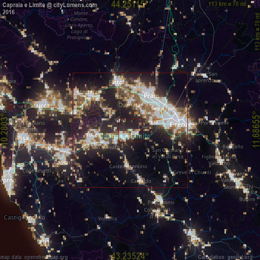
Analysis of Capraia e Limite night lights 2016
Square area 10x10 km:
 8.79%
8.79%90-99
9.55%80-89
3.64%70-79
2.88%60-69
5.45%50-59
4.09%40-49
4.7%30-39
7.88%20-29
23.33%10-19
29.7%0-9
0%Square area 50x50 km:
6.52%90-99
6.66%80-89
2.67%70-79
3.02%60-69
3.68%50-59
4.73%40-49
4.95%30-39
4.69%20-29
12.17%10-19
17.73%0-9
33.17%Clear (daylight) street map image can be seen on geolist.org.
Map coordinates:
44° 15' 4.1" North, 10° 16' 49.1" East
43° 44' 43.3" North, 10° 59' 0.3" East
43° 14' 6.9" North, 11° 41' 11.6" East
Some cities around Capraia e Limite sort by population:
• Empoli
4.2 km =2.6 mi,  223°
223°
• Signa
11.1 km =6.9 mi,  60°
60°
• Lastra a Signa
10.7 km =6.6 mi,  75°
75°
• Montelupo Fiorentino
2.8 km =1.7 mi,  129°
129°
• Spicchio-Sovigliana
3.9 km =2.4 mi,  244°
244°
• Poggio A Caiano
9.4 km =5.8 mi,  35°
35°
• Seano
9.9 km =6.2 mi,  17°
17°
• Lamporecchio
11 km =6.8 mi,  309°
309°
6534684 (p: 5,920)
Sources (retrieved 2019-11-25):
» Earth at Night: Flat Maps 2012, 2016