Casarano night lights from space
Night Light of Casarano (Apulia) from space (Italy) Src. Average luminocity for 10x10km area is 45.7744% and for 50x50km: 24.8668%.
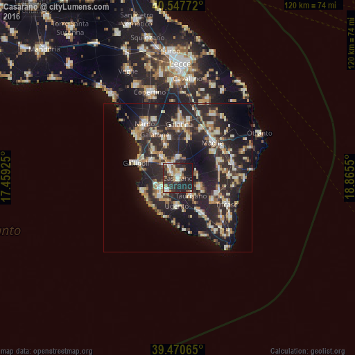
Analysis of Casarano night lights 2016
Square area 10x10 km:
 7.14%
7.14%90-99
9.42%80-89
4.87%70-79
3.41%60-69
7.14%50-59
2.92%40-49
6.33%30-39
12.34%20-29
28.41%10-19
17.86%0-9
0.16%Square area 50x50 km:
2.22%90-99
4.68%80-89
3.23%70-79
2.81%60-69
3.08%50-59
2.05%40-49
2.52%30-39
5.41%20-29
15.83%10-19
18.62%0-9
39.55%Clear (daylight) street map image can be seen on geolist.org.
Map coordinates:
40° 32' 51.8" North, 17° 27' 33.3" East
40° 0' 40.7" North, 18° 9' 44.5" East
39° 28' 14.3" North, 18° 51' 55.8" East
Some cities around Casarano sort by population:
• Taviano
7.6 km =4.7 mi,  244°
244°
• Matino
3.1 km =1.9 mi,  314°
314°
• Taurisano
7.5 km =4.7 mi,  143°
143°
• Racale
8.2 km =5.1 mi,  227°
227°
• Ruffano
8.1 km =5 mi,  113°
113°
• Parabita
5.4 km =3.4 mi,  325°
325°
• Melissano
5.5 km =3.4 mi,  219°
219°
• Collepasso
6.7 km =4.2 mi,  359°
359°
2525207 (p: 19,359)
Sources (retrieved 2019-11-25):
» Earth at Night: Flat Maps 2012, 2016