Carovigno night lights from space
Night Light of Carovigno (Apulia) from space (Italy) Src. Average luminocity for 10x10km area is 25.4221% and for 50x50km: 13.9142%.
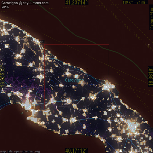
Analysis of Carovigno night lights 2016
Square area 10x10 km:
 3.25%
3.25%90-99
1.95%80-89
1.95%70-79
1.3%60-69
4.38%50-59
5.03%40-49
3.08%30-39
4.71%20-29
2.11%10-19
59.9%0-9
12.34%Square area 50x50 km:
1.34%90-99
1.79%80-89
1.43%70-79
1.36%60-69
1.91%50-59
1.71%40-49
1.28%30-39
2.15%20-29
4.05%10-19
18.05%0-9
64.94%Clear (daylight) street map image can be seen on geolist.org.
Map coordinates:
41° 14' 13.7" North, 16° 57' 19.3" East
40° 42' 22.5" North, 17° 39' 30.5" East
40° 10' 16" North, 18° 21' 41.8" East
Some cities around Carovigno sort by population:
• Francavilla Fontana
20.4 km =12.7 mi,  197°
197°
• Mesagne
20.7 km =12.9 mi,  142°
142°
• Ostuni
7.3 km =4.5 mi,  290°
290°
• San Vito dei Normanni
6.9 km =4.3 mi, 142°
• Ceglie Messapica
13.7 km =8.5 mi,  240°
240°
• Latiano
18 km =11.2 mi,  163°
163°
• San Michele Salentino
8.6 km =5.3 mi,  194°
194°
• Cisternino
20 km =12.4 mi,  281°
281°
3180462 (p: 14,043)
Sources (retrieved 2019-11-25):
» Earth at Night: Flat Maps 2012, 2016