Latiano night lights from space
Night Light of Latiano (Apulia) from space (Italy) Src. Average luminocity for 10x10km area is 16.3539% and for 50x50km: 19.4728%.
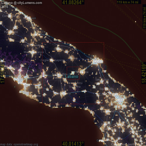
Analysis of Latiano night lights 2016
Square area 10x10 km:
 0.97%
0.97%90-99
2.11%80-89
1.62%70-79
1.3%60-69
1.46%50-59
1.62%40-49
0.97%30-39
2.44%20-29
2.11%10-19
28.57%0-9
56.82%Square area 50x50 km:
2.35%90-99
2.9%80-89
2.03%70-79
1.62%60-69
2.34%50-59
2.01%40-49
1.96%30-39
2.33%20-29
4.45%10-19
29.56%0-9
48.44%Clear (daylight) street map image can be seen on geolist.org.
Map coordinates:
41° 4' 57.5" North, 17° 0' 55.6" East
40° 33' 1.9" North, 17° 43' 6.8" East
40° 0' 50.9" North, 18° 25' 18.1" East
Some cities around Latiano sort by population:
• Francavilla Fontana
11.5 km =7.1 mi,  259°
259°
• Mesagne
7.6 km =4.7 mi,  83°
83°
• San Vito dei Normanni
11.8 km =7.3 mi,  355°
355°
• Oria
8.5 km =5.3 mi,  228°
228°
• San Pancrazio Salentino
17.7 km =11 mi,  146°
146°
• Torre Santa Susanna
9.4 km =5.8 mi,  169°
169°
• Erchie
12.8 km =8 mi, 173°
• San Michele Salentino
11.6 km =7.2 mi,  321°
321°
3175061 (p: 14,662)
Sources (retrieved 2019-11-25):
» Earth at Night: Flat Maps 2012, 2016