Cisternino night lights from space
Night Light of Cisternino (Apulia) from space (Italy) Src. Average luminocity for 10x10km area is 15.5877% and for 50x50km: 18.7074%.
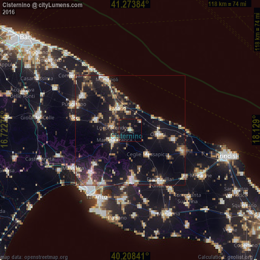
Analysis of Cisternino night lights 2016
Square area 10x10 km:
 0.65%
0.65%90-99
1.14%80-89
1.79%70-79
0.65%60-69
2.27%50-59
0.81%40-49
3.41%30-39
2.44%20-29
4.55%10-19
31.49%0-9
50.81%Square area 50x50 km:
1.74%90-99
2.54%80-89
2.13%70-79
1.84%60-69
2.5%50-59
2.61%40-49
2.18%30-39
3.44%20-29
6.31%10-19
21.1%0-9
53.61%Clear (daylight) street map image can be seen on geolist.org.
Map coordinates:
41° 16' 25.8" North, 16° 43' 21.9" East
40° 44' 35.7" North, 17° 25' 33.1" East
40° 12' 30.3" North, 18° 7' 44.4" East
Some cities around Cisternino sort by population:
• Martina Franca
8.6 km =5.3 mi,  239°
239°
• Ostuni
12.8 km =8 mi,  97°
97°
• Fasano
11.7 km =7.3 mi,  331°
331°
• Ceglie Messapica
13.2 km =8.2 mi,  144°
144°
• Carovigno
20 km =12.4 mi, 101°
• Alberobello
16.6 km =10.3 mi,  286°
286°
• Locorotondo
8.7 km =5.4 mi,  279°
279°
• Villa Castelli
18.3 km =11.4 mi,  166°
166°
3178630 (p: 5,746)
Sources (retrieved 2019-11-25):
» Earth at Night: Flat Maps 2012, 2016