Brignano Gera d'Adda night lights from space
Night Light of Brignano Gera d'Adda (Lombardy) from space (Italy) Src. Average luminocity for 10x10km area is 65.7318% and for 50x50km: 56.4705%.
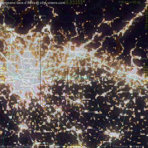
Analysis of Brignano Gera d'Adda night lights 2016
Square area 10x10 km:
 10.91%
90-99
14.24%80-89
5.91%70-79
12.58%60-69
11.82%50-59
13.94%40-49
13.03%30-39
16.06%20-29
1.52%10-19
0%0-9
0%Square area 50x50 km:
12.23%90-99
13.53%80-89
5.65%70-79
6.81%60-69
8.31%50-59
8.06%40-49
7.26%30-39
8.61%20-29
14.58%10-19
10.47%0-9
4.5%Clear (daylight) street map image can be seen on geolist.org.
Map coordinates:
46° 2' 0.7" North, 8° 56' 28" East
45° 32' 35.7" North, 9° 38' 39.3" East
45° 2' 55.1" North, 10° 20' 50.5" East
Some cities around Brignano Gera d'Adda sort by population:
• Treviglio
4.8 km =3 mi,  238°
238°
• Caravaggio
5.2 km =3.2 mi,  182°
182°
• Cologno al Serio
6.2 km =3.9 mi,  54°
54°
• Urgnano
7.4 km =4.6 mi,  32°
32°
• Verdellino
7 km =4.3 mi,  336°
336°
• Verdello
6.8 km =4.2 mi,  349°
349°
• Ciserano
6 km =3.7 mi,  325°
325°
• Spirano
4.7 km =2.9 mi,  24°
24°
3181532 (p: 5,920)
Sources (retrieved 2019-11-25):
» Earth at Night: Flat Maps 2012, 2016