Caravaggio night lights from space
Night Light of Caravaggio (Lombardy) from space (Italy) Src. Average luminocity for 10x10km area is 59.8127% and for 50x50km: 54.8056%.
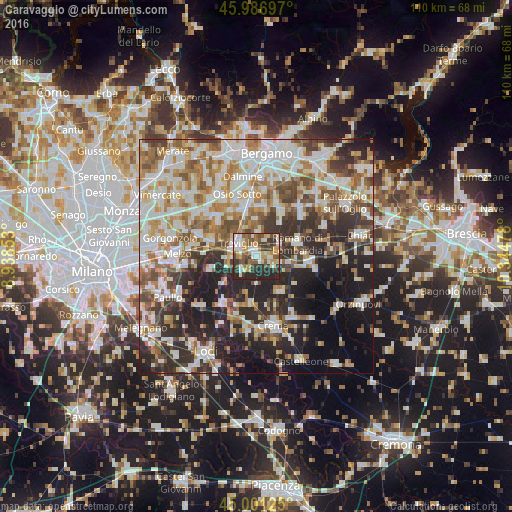
Analysis of Caravaggio night lights 2016
Square area 10x10 km:
 9.84%
9.84%90-99
13.49%80-89
6.67%70-79
11.9%60-69
5.24%50-59
9.37%40-49
11.59%30-39
11.59%20-29
20.16%10-19
0.16%0-9
0%Square area 50x50 km:
12.15%90-99
13.39%80-89
5.32%70-79
6.59%60-69
8.08%50-59
7.42%40-49
6.55%30-39
7.25%20-29
14.19%10-19
11.49%0-9
7.57%Clear (daylight) street map image can be seen on geolist.org.
Map coordinates:
45° 59' 13.1" North, 8° 56' 18.7" East
45° 29' 46.6" North, 9° 38' 29.9" East
45° 0' 4.5" North, 10° 20' 41.2" East
Some cities around Caravaggio sort by population:
• Treviglio
4.8 km =3 mi,  304°
304°
• Romano di Lombardia
9.2 km =5.7 mi,  72°
72°
• Cassano d'Adda
10.4 km =6.5 mi,  288°
288°
• Cologno al Serio
10.3 km =6.4 mi,  30°
30°
• Rivolta d'Adda
10.5 km =6.5 mi,  253°
253°
• Fara Gera d'Adda
10.6 km =6.6 mi,  309°
309°
• Brignano Gera d'Adda
5.2 km =3.2 mi,  2°
2°
• Spirano
9.7 km =6 mi,  12°
12°
3180580 (p: 13,340)
Sources (retrieved 2019-11-25):
» Earth at Night: Flat Maps 2012, 2016