Bondeno night lights from space
Night Light of Bondeno (Emilia-Romagna) from space (Italy) Src. Average luminocity for 10x10km area is 16.4571% and for 50x50km: 19.7806%.
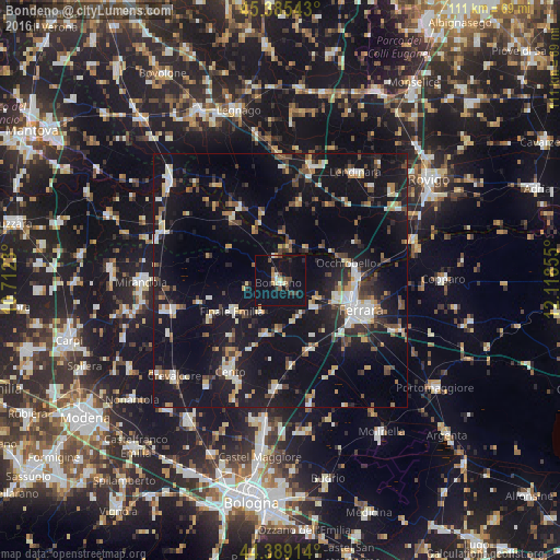
Analysis of Bondeno night lights 2016
Square area 10x10 km:
 0.79%
0.79%90-99
1.43%80-89
1.9%70-79
1.59%60-69
1.27%50-59
2.38%40-49
2.86%30-39
2.22%20-29
2.38%10-19
22.7%0-9
60.48%Square area 50x50 km:
1.96%90-99
3.31%80-89
1.77%70-79
1.74%60-69
1.91%50-59
2.18%40-49
3.26%30-39
2.55%20-29
4.73%10-19
26.11%0-9
50.47%Clear (daylight) street map image can be seen on geolist.org.
Map coordinates:
45° 23' 7.5" North, 10° 42' 44.3" East
44° 53' 22" North, 11° 24' 55.5" East
44° 23' 20.9" North, 12° 7' 6.8" East
Some cities around Bondeno sort by population:
• Ferrara
17.1 km =10.6 mi,  109°
109°
• Cento
20.3 km =12.6 mi,  209°
209°
• Finale Emilia
11.4 km =7.1 mi,  237°
237°
• Santa Maria Maddalena
15.1 km =9.4 mi,  84°
84°
• San Pietro in Casale
21 km =13 mi,  182°
182°
• San Felice sul Panaro
22.6 km =14 mi,  254°
254°
• Pieve di Cento
21.3 km =13.2 mi,  203°
203°
• Poggio Renatico
14.9 km =9.3 mi,  157°
157°
3181891 (p: 7,519)
Sources (retrieved 2019-11-25):
» Earth at Night: Flat Maps 2012, 2016