Finale Emilia night lights from space
Night Light of Finale Emilia (Emilia-Romagna) from space (Italy) Src. Average luminocity for 10x10km area is 24.0111% and for 50x50km: 22.2762%.
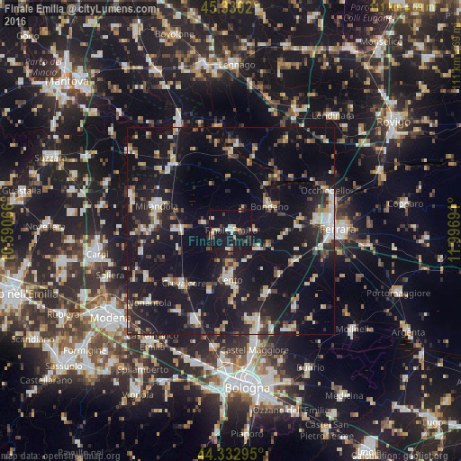
Analysis of Finale Emilia night lights 2016
Square area 10x10 km:
 1.75%
1.75%90-99
5.87%80-89
3.33%70-79
1.43%60-69
0.63%50-59
2.22%40-49
2.54%30-39
0.95%20-29
5.08%10-19
51.11%0-9
25.08%Square area 50x50 km:
2.37%90-99
3.87%80-89
2.32%70-79
1.94%60-69
1.94%50-59
2.25%40-49
3%30-39
2.67%20-29
6.57%10-19
32.21%0-9
40.84%Clear (daylight) street map image can be seen on geolist.org.
Map coordinates:
45° 19' 48.7" North, 10° 35' 26.4" East
44° 50' 1.4" North, 11° 17' 37.6" East
44° 19' 58.6" North, 11° 59' 48.9" East
Some cities around Finale Emilia sort by population:
• Cento
11.4 km =7.1 mi,  182°
182°
• Crevalcore
17.1 km =10.6 mi,  222°
222°
• San Pietro in Casale
17.2 km =10.7 mi,  149°
149°
• Bondeno
11.4 km =7.1 mi,  57°
57°
• San Felice sul Panaro
12.3 km =7.6 mi,  271°
271°
• Pieve di Cento
13.5 km =8.4 mi,  174°
174°
• Poggio Renatico
17 km =10.6 mi,  116°
116°
• Decima
14.6 km =9.1 mi,  200°
200°
3176983 (p: 9,044)
Sources (retrieved 2019-11-25):
» Earth at Night: Flat Maps 2012, 2016