San Pietro in Casale night lights from space
Night Light of San Pietro in Casale (Emilia-Romagna) from space (Italy) Src. Average luminocity for 10x10km area is 20.0106% and for 50x50km: 27.8385%.
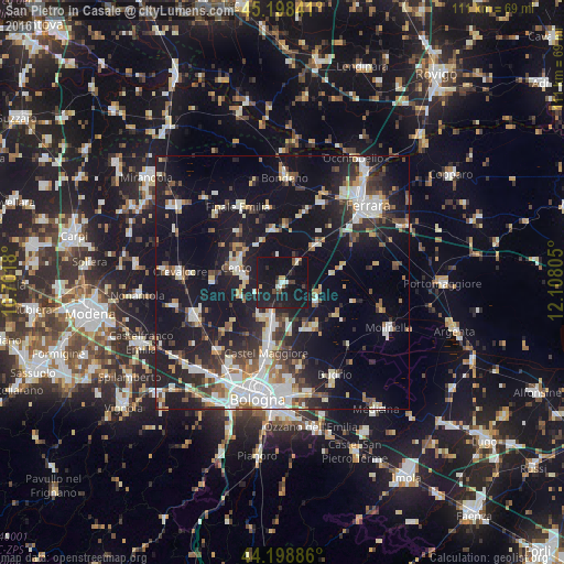
Analysis of San Pietro in Casale night lights 2016
Square area 10x10 km:
 1.52%
1.52%90-99
2.58%80-89
0.45%70-79
1.52%60-69
1.21%50-59
1.67%40-49
2.88%30-39
1.67%20-29
7.73%10-19
51.52%0-9
27.27%Square area 50x50 km:
4.96%90-99
5.84%80-89
2.4%70-79
2.2%60-69
2.51%50-59
2.94%40-49
3.55%30-39
4.06%20-29
8.19%10-19
26.61%0-9
36.74%Clear (daylight) street map image can be seen on geolist.org.
Map coordinates:
45° 11' 54.3" North, 10° 42' 6.5" East
44° 42' 2.8" North, 11° 24' 17.7" East
44° 11' 55.9" North, 12° 6' 29" East
Some cities around San Pietro in Casale sort by population:
• Cento
9.9 km =6.2 mi,  289°
289°
• Castel Maggiore
14.2 km =8.8 mi,  194°
194°
• Progresso
15 km =9.3 mi, 192°
• Pieve di Cento
7.7 km =4.8 mi,  280°
280°
• San Giorgio di Piano
6.4 km =4 mi,  202°
202°
• Granarolo dell'Emilia e Viadagola
16.7 km =10.4 mi,  169°
169°
• Poggio Renatico
9.7 km =6 mi,  41°
41°
• Decima
13.9 km =8.6 mi,  274°
274°
3167824 (p: 8,022)
Sources (retrieved 2019-11-25):
» Earth at Night: Flat Maps 2012, 2016