Pieve di Cento night lights from space
Night Light of Pieve di Cento (Emilia-Romagna) from space (Italy) Src. Average luminocity for 10x10km area is 32.7167% and for 50x50km: 29.984%.
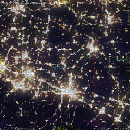
Analysis of Pieve di Cento night lights 2016
Square area 10x10 km:
 3.94%
3.94%90-99
6.06%80-89
3.94%70-79
5%60-69
2.58%50-59
2.12%40-49
2.27%30-39
1.97%20-29
10.76%10-19
58.33%0-9
3.03%Square area 50x50 km:
5.03%90-99
6.13%80-89
2.94%70-79
2.43%60-69
2.67%50-59
2.97%40-49
3.75%30-39
4.3%20-29
10.73%10-19
30.52%0-9
28.53%Clear (daylight) street map image can be seen on geolist.org.
Map coordinates:
45° 12' 37.6" North, 10° 36' 22" East
44° 42' 46.5" North, 11° 18' 33.2" East
44° 12' 40" North, 12° 0' 44.5" East
Some cities around Pieve di Cento sort by population:
• Cento
2.7 km =1.7 mi,  319°
319°
• San Giovanni in Persiceto
12.9 km =8 mi,  230°
230°
• Finale Emilia
13.5 km =8.4 mi,  354°
354°
• Crevalcore
12.8 km =8 mi,  273°
273°
• San Pietro in Casale
7.7 km =4.8 mi,  100°
100°
• San Giorgio di Piano
8.9 km =5.5 mi,  144°
144°
• Sant'Agata Bolognese
15.1 km =9.4 mi,  247°
247°
• Decima
6.3 km =3.9 mi, 267°
3170752 (p: 6,254)
Sources (retrieved 2019-11-25):
» Earth at Night: Flat Maps 2012, 2016