Arese night lights from space
Night Light of Arese (Lombardy) from space (Italy) Src. Average luminocity for 10x10km area is 97.4288% and for 50x50km: 75.9693%.
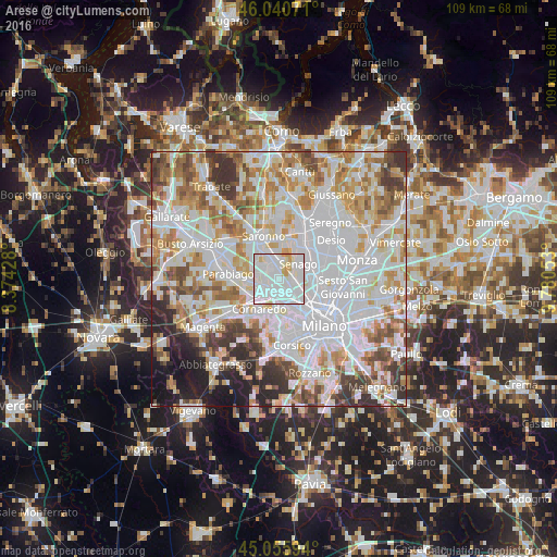
Analysis of Arese night lights 2016
Square area 10x10 km:
100  58.33%
90-99 32.58%
80-89 5.15%
70-79 3.94%
60-69 0%
50-59 0%
40-49 0%
30-39 0%
20-29 0%
10-19 0%
0-9 0%
58.33%90-99
32.58%80-89
5.15%70-79
3.94%60-69
0%50-59
0%40-49
0%30-39
0%20-29
0%10-19
0%0-9
0%Square area 50x50 km:
100 29.38%
90-99 19.51%
80-89 7.3%
70-79 8.48%
60-69 9.04%
50-59 5.75%
40-49 5.5%
30-39 5.72%
20-29 4.67%
10-19 4.29%
0-9 0.37%
29.38%90-99
19.51%80-89
7.3%70-79
8.48%60-69
9.04%50-59
5.75%40-49
5.5%30-39
5.72%20-29
4.67%10-19
4.29%0-9
0.37%Clear (daylight) street map image can be seen on geolist.org.
Map coordinates:
46° 2' 26.6" North, 8° 22' 27.4" East
45° 33' 1.7" North, 9° 4' 38.7" East
45° 3' 21.4" North, 9° 46' 49.9" East
Some cities around Arese sort by population:
• Rho
3.5 km =2.2 mi,  235°
235°
• Bollate
3.4 km =2.1 mi,  97°
97°
• Garbagnate Milanese
2.7 km =1.7 mi,  356°
356°
• Lainate
4.6 km =2.9 mi,  300°
300°
• Senago
4.7 km =2.9 mi,  53°
53°
• Cesate
5 km =3.1 mi, 358°
• Baranzate
4 km =2.5 mi,  129°
129°
• Pero
4.5 km =2.8 mi,  170°
170°
3182886 (p: 19,138)
Sources (retrieved 2019-11-25):
» Earth at Night: Flat Maps 2012, 2016