Bollate night lights from space
Night Light of Bollate (Lombardy) from space (Italy) Src. Average luminocity for 10x10km area is 98.103% and for 50x50km: 76.7949%.
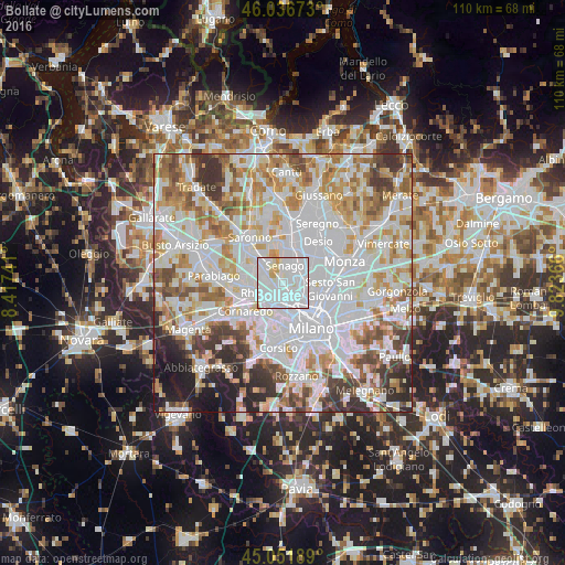

Analysis of Bollate night lights 2016
Square area 10x10 km:
 72.73%
90-99
20.15%80-89
3.94%70-79
3.18%60-69
0%50-59
0%40-49
0%30-39
0%20-29
0%10-19
0%0-9
0%Square area 50x50 km:
29.88%90-99
19.94%80-89
7.28%70-79
8.61%60-69
8.9%50-59
5.81%40-49
5.33%30-39
5.9%20-29
4.67%10-19
3.63%0-9
0.07%Clear (daylight) street map image can be seen on geolist.org.
Map coordinates:
46° 2' 12.2" North, 8° 25' 2.7" East
45° 32' 47.3" North, 9° 7' 13.9" East
45° 3' 6.8" North, 9° 49' 25.2" East
Some cities around Bollate sort by population:
• Paderno Dugnano
4.3 km =2.7 mi,  54°
54°
• Garbagnate Milanese
4.7 km =2.9 mi,  311°
311°
• Senago
3.3 km =2.1 mi,  7°
7°
• Novate Milanese
2.3 km =1.4 mi,  140°
140°
• Cormano
3.1 km =1.9 mi,  84°
84°
• Arese
3.4 km =2.1 mi,  277°
277°
• Baranzate
2.2 km =1.4 mi,  186°
186°
• Pero
4.8 km =3 mi,  212°
212°
3181931 (p: 35,235)
Sources (retrieved 2019-11-25):
» Earth at Night: Flat Maps 2012, 2016