San Pietro in Cariano night lights from space
Night Light of San Pietro in Cariano (Veneto) from space (Italy) Src. Average luminocity for 10x10km area is 53.647% and for 50x50km: 29.7285%.
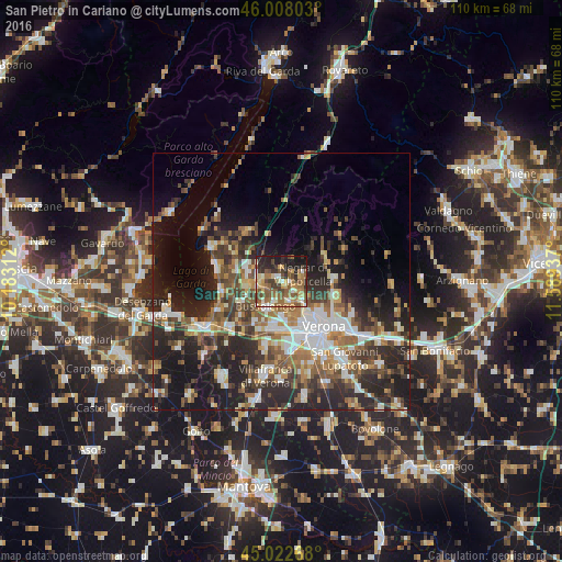
Analysis of San Pietro in Cariano night lights 2016
Square area 10x10 km:
 3.94%
3.94%90-99
7.58%80-89
7.88%70-79
8.64%60-69
12.73%50-59
18.03%40-49
8.03%30-39
8.94%20-29
13.79%10-19
10.45%0-9
0%Square area 50x50 km:
4.48%90-99
5.19%80-89
2.74%70-79
3.07%60-69
4.76%50-59
5.32%40-49
4.98%30-39
5.24%20-29
12.2%10-19
13.83%0-9
38.2%Clear (daylight) street map image can be seen on geolist.org.
Map coordinates:
46° 0' 28.9" North, 10° 10' 59.2" East
45° 31' 3" North, 10° 53' 10.5" East
45° 1' 21.6" North, 11° 35' 21.7" East
Some cities around San Pietro in Cariano sort by population:
• Verona
12.4 km =7.7 mi,  141°
141°
• Bussolengo
6 km =3.7 mi,  205°
205°
• Pescantina
3.8 km =2.4 mi,  201°
201°
• Sant'Ambrogio di Valpollicella
3.9 km =2.4 mi,  275°
275°
• Lugagnano
9.4 km =5.8 mi,  181°
181°
• Sommacampagna
12.9 km =8 mi,  194°
194°
• Negrar
4.3 km =2.7 mi,  72°
72°
• Arbizzano-Santa Maria
4.8 km =3 mi,  121°
121°
6534260 (p: 6,119)
Sources (retrieved 2019-11-25):
» Earth at Night: Flat Maps 2012, 2016