Negrar night lights from space
Night Light of Negrar (Veneto) from space (Italy) Src. Average luminocity for 10x10km area is 37.6242% and for 50x50km: 28.5939%.
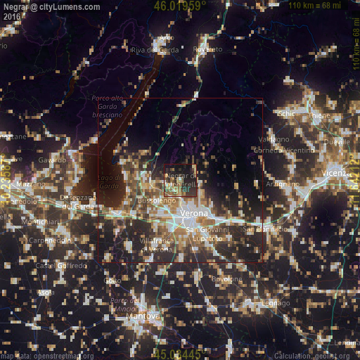
Analysis of Negrar night lights 2016
Square area 10x10 km:
 1.36%
1.36%90-99
2.42%80-89
6.21%70-79
5.3%60-69
6.06%50-59
10.45%40-49
5.45%30-39
11.06%20-29
20.45%10-19
24.7%0-9
6.52%Square area 50x50 km:
4.39%90-99
4.97%80-89
2.67%70-79
2.89%60-69
4.59%50-59
5.12%40-49
4.9%30-39
5.23%20-29
11.47%10-19
11.86%0-9
41.91%Clear (daylight) street map image can be seen on geolist.org.
Map coordinates:
46° 1' 10.5" North, 10° 14' 9.1" East
45° 31' 45" North, 10° 56' 20.4" East
45° 2' 4" North, 11° 38' 31.6" East
Some cities around Negrar sort by population:
• Verona
11.6 km =7.2 mi,  162°
162°
• Bussolengo
9.4 km =5.8 mi,  224°
224°
• Pescantina
7.4 km =4.6 mi,  228°
228°
• Sant'Ambrogio di Valpollicella
8.1 km =5 mi,  263°
263°
• Lugagnano
11.5 km =7.1 mi,  201°
201°
• San Pietro in Cariano
4.3 km =2.7 mi,  252°
252°
• Montorio
12.6 km =7.8 mi,  128°
128°
• Arbizzano-Santa Maria
3.8 km =2.4 mi,  180°
180°
3172338 (p: 6,464)
Sources (retrieved 2019-11-25):
» Earth at Night: Flat Maps 2012, 2016