Agrate Brianza night lights from space
Night Light of Agrate Brianza (Lombardy) from space (Italy) Src. Average luminocity for 10x10km area is 92.4318% and for 50x50km: 75.2229%.
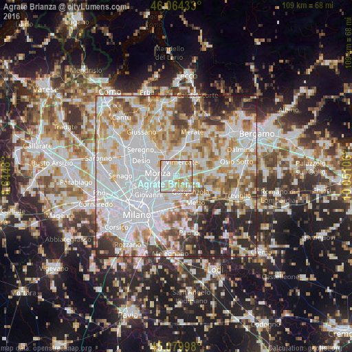
Analysis of Agrate Brianza night lights 2016
Square area 10x10 km:
 38.33%
90-99
33.33%80-89
10%70-79
13.64%60-69
4.09%50-59
0.61%40-49
0%30-39
0%20-29
0%10-19
0%0-9
0%Square area 50x50 km:
28.67%90-99
18.93%80-89
7.06%70-79
8.88%60-69
8.89%50-59
6.3%40-49
5.21%30-39
5.3%20-29
7.16%10-19
3.61%0-9
0%Clear (daylight) street map image can be seen on geolist.org.
Map coordinates:
46° 3' 51.6" North, 8° 38' 41.3" East
45° 34' 27.5" North, 9° 20' 52.5" East
45° 4' 47.9" North, 10° 3' 3.8" East
Some cities around Agrate Brianza sort by population:
• Brugherio
4.5 km =2.8 mi,  238°
238°
• Vimercate
4.8 km =3 mi,  18°
18°
• Concorezzo
1.9 km =1.2 mi,  325°
325°
• Villasanta
4.7 km =2.9 mi,  318°
318°
• Carugate
2.8 km =1.7 mi,  192°
192°
• Bussero
4.9 km =3 mi,  157°
157°
• Pessano Con Bornago
3.8 km =2.4 mi,  136°
136°
• Caponago
2.3 km =1.4 mi,  111°
111°
3183417 (p: 14,493)
Sources (retrieved 2019-11-25):
» Earth at Night: Flat Maps 2012, 2016