Villasanta night lights from space
Night Light of Villasanta (Lombardy) from space (Italy) Src. Average luminocity for 10x10km area is 95.4242% and for 50x50km: 75.8552%.
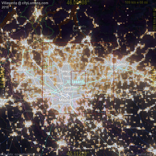
Analysis of Villasanta night lights 2016
Square area 10x10 km:
 50.91%
90-99
29.85%80-89
10%70-79
8.03%60-69
1.21%50-59
0%40-49
0%30-39
0%20-29
0%10-19
0%0-9
0%Square area 50x50 km:
28.95%90-99
19.3%80-89
7.34%70-79
8.84%60-69
8.89%50-59
6.39%40-49
5.5%30-39
5.21%20-29
5.52%10-19
3.71%0-9
0.35%Clear (daylight) street map image can be seen on geolist.org.
Map coordinates:
46° 5' 45.9" North, 8° 36' 17.5" East
45° 36' 22.8" North, 9° 18' 28.7" East
45° 6' 44.2" North, 10° 0' 40" East
Some cities around Villasanta sort by population:
• Monza
4 km =2.5 mi,  223°
223°
• Arcore
2.6 km =1.6 mi,  29°
29°
• Concorezzo
2.8 km =1.7 mi,  134°
134°
• Agrate Brianza
4.7 km =2.9 mi,  138°
138°
• Biassono
3.8 km =2.4 mi,  310°
310°
• Lesmo
4.7 km =2.9 mi,  359°
359°
• Vedano al Lambro
3.1 km =1.9 mi,  274°
274°
• Macherio
4.6 km =2.9 mi,  324°
324°
3164138 (p: 13,424)
Sources (retrieved 2019-11-25):
» Earth at Night: Flat Maps 2012, 2016