Caponago night lights from space
Night Light of Caponago (Lombardy) from space (Italy) Src. Average luminocity for 10x10km area is 90.1091% and for 50x50km: 74.13%.
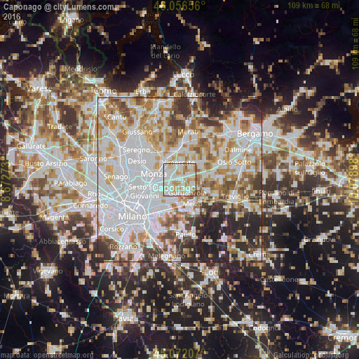
Analysis of Caponago night lights 2016
Square area 10x10 km:
 31.97%
90-99
32.73%80-89
10.76%70-79
17.42%60-69
4.7%50-59
2.12%40-49
0.3%30-39
0%20-29
0%10-19
0%0-9
0%Square area 50x50 km:
28.09%90-99
18.12%80-89
6.76%70-79
8.88%60-69
8.78%50-59
6.51%40-49
5.5%30-39
5.9%20-29
7.79%10-19
3.69%0-9
0%Clear (daylight) street map image can be seen on geolist.org.
Map coordinates:
46° 3' 23.6" North, 8° 40' 21.8" East
45° 33' 59.3" North, 9° 22' 33.1" East
45° 4' 19.5" North, 10° 4' 44.3" East
Some cities around Caponago sort by population:
• Gorgonzola
4.6 km =2.9 mi,  150°
150°
• Concorezzo
4.1 km =2.5 mi,  306°
306°
• Agrate Brianza
2.3 km =1.4 mi,  291°
291°
• Carugate
3.3 km =2.1 mi,  236°
236°
• Bussero
3.6 km =2.2 mi,  184°
184°
• Pessano Con Bornago
2 km =1.2 mi,  167°
167°
• Cavenago di Brianza
3.4 km =2.1 mi,  57°
57°
• Cambiago
4.9 km =3 mi,  71°
71°
6535768 (p: 5,027)
Sources (retrieved 2019-11-25):
» Earth at Night: Flat Maps 2012, 2016