Bussero night lights from space
Night Light of Bussero (Lombardy) from space (Italy) Src. Average luminocity for 10x10km area is 89.6636% and for 50x50km: 73.7668%.
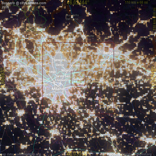
Analysis of Bussero night lights 2016
Square area 10x10 km:
 34.09%
90-99
31.67%80-89
7.88%70-79
14.85%60-69
7.73%50-59
3.48%40-49
0.3%30-39
0%20-29
0%10-19
0%0-9
0%Square area 50x50 km:
28.02%90-99
17.86%80-89
6.79%70-79
8.9%60-69
8.44%50-59
6.42%40-49
5.18%30-39
5.98%20-29
9.03%10-19
3.38%0-9
0%Clear (daylight) street map image can be seen on geolist.org.
Map coordinates:
46° 1' 28" North, 8° 40' 8.1" East
45° 32' 2.7" North, 9° 22' 19.4" East
45° 2' 21.8" North, 10° 4' 30.6" East
Some cities around Bussero sort by population:
• Pioltello
4.9 km =3 mi,  221°
221°
• Cernusco sul Naviglio
3.2 km =2 mi,  252°
252°
• Gorgonzola
2.6 km =1.6 mi,  98°
98°
• Carugate
3 km =1.9 mi,  305°
305°
• Cassina de' Pecchi
2.2 km =1.4 mi,  205°
205°
• Vignate
3.9 km =2.4 mi,  174°
174°
• Pessano Con Bornago
1.9 km =1.2 mi,  23°
23°
• Caponago
3.6 km =2.2 mi,  4°
4°
6534246 (p: 8,529)
Sources (retrieved 2019-11-25):
» Earth at Night: Flat Maps 2012, 2016