Carugate night lights from space
Night Light of Carugate (Lombardy) from space (Italy) Src. Average luminocity for 10x10km area is 93.6015% and for 50x50km: 75.0761%.
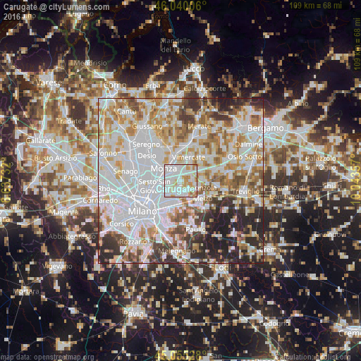
Analysis of Carugate night lights 2016
Square area 10x10 km:
 43.03%
90-99
33.33%80-89
7.73%70-79
11.21%60-69
4.55%50-59
0.15%40-49
0%30-39
0%20-29
0%10-19
0%0-9
0%Square area 50x50 km:
28.7%90-99
18.78%80-89
7.02%70-79
8.83%60-69
8.68%50-59
6.33%40-49
5.19%30-39
5.37%20-29
8.03%10-19
3.08%0-9
0%Clear (daylight) street map image can be seen on geolist.org.
Map coordinates:
46° 2' 24.2" North, 8° 38' 14.4" East
45° 32' 59.4" North, 9° 20' 25.6" East
45° 3' 19" North, 10° 2' 36.9" East
Some cities around Carugate sort by population:
• Brugherio
3.2 km =2 mi,  276°
276°
• Cernusco sul Naviglio
2.8 km =1.7 mi,  192°
192°
• Concorezzo
4.3 km =2.7 mi,  353°
353°
• Agrate Brianza
2.8 km =1.7 mi,  12°
12°
• Cassina de' Pecchi
4 km =2.5 mi,  157°
157°
• Bussero
3 km =1.9 mi,  125°
125°
• Pessano Con Bornago
3.2 km =2 mi,  90°
90°
• Caponago
3.3 km =2.1 mi,  56°
56°
3180389 (p: 13,421)
Sources (retrieved 2019-11-25):
» Earth at Night: Flat Maps 2012, 2016