Āq Qāyeh night lights from space
Night Light of Āq Qāyeh (Golestan) from space (Iran) Src. Average luminocity for 10x10km area is 42.1939% and for 50x50km: 7.3927%.
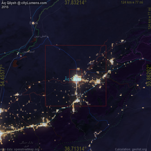
Analysis of Āq Qāyeh night lights 2016
Square area 10x10 km:
 9.86%
9.86%90-99
9.86%80-89
9.35%70-79
4.59%60-69
0.85%50-59
2.04%40-49
0.85%30-39
5.61%20-29
12.07%10-19
27.38%0-9
17.52%Square area 50x50 km:
0.73%90-99
0.72%80-89
1.07%70-79
0.88%60-69
0.76%50-59
0.93%40-49
0.86%30-39
1.65%20-29
2.23%10-19
8.3%0-9
81.87%Clear (daylight) street map image can be seen on geolist.org.
Map coordinates:
37° 49' 55.7" North, 54° 27' 20.8" East
37° 16' 29" North, 55° 9' 32" East
36° 42' 47.3" North, 55° 51' 43.3" East
Some cities around Āq Qāyeh sort by population:
• Gorgān
79.6 km =49.5 mi,  232°
232°
• Shahrud
96.6 km =60 mi,  189°
189°
• Gonbad-e Kāvūs
2.8 km =1.7 mi,  164°
164°
• Behshahr
156.7 km =97.4 mi,  245°
245°
• Dāmghān
142.9 km =88.8 mi,  210°
210°
• Nekā
179.2 km =111.3 mi, 247°
• Āzādshahr
21 km =13 mi,  176°
176°
• Kalāleh
31.7 km =19.7 mi,  68°
68°
39874 (p: 5,114)
Sources (retrieved 2019-11-25):
» Earth at Night: Flat Maps 2012, 2016