Ṟuwandiz night lights from space
Night Light of Ṟuwandiz (Arbīl) from space (Iraq) Src. Average luminocity for 10x10km area is 42.1557% and for 50x50km: 7.2237%.
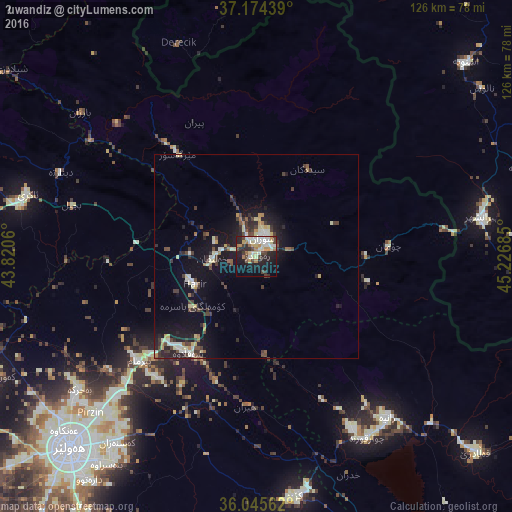

Analysis of Ṟuwandiz night lights 2016
Square area 10x10 km:
 5.13%
5.13%90-99
11.72%80-89
6.59%70-79
4.95%60-69
5.31%50-59
2.2%40-49
6.04%30-39
4.95%20-29
12.27%10-19
26.56%0-9
14.29%Square area 50x50 km:
0.46%90-99
1.44%80-89
1.04%70-79
0.57%60-69
0.68%50-59
0.43%40-49
1.44%30-39
1.56%20-29
2.1%10-19
6.84%0-9
83.46%Clear (daylight) street map image can be seen on geolist.org.
Map coordinates:
37° 10' 27.8" North, 43° 49' 14.2" East
36° 36' 43.5" North, 44° 31' 25.4" East
36° 2' 44.2" North, 45° 13' 36.7" East
Some cities around Ṟuwandiz sort by population:
• Erbil
66.1 km =41.1 mi,  223°
223°
• Soran
4.9 km =3 mi,  21°
21°
• Naqadeh, IR
85.9 km =53.4 mi,  63°
63°
• Piranshahr, IR
56 km =34.8 mi,  79°
79°
• Oshnavīyeh, IR
69.8 km =43.4 mi,  47°
47°
• Koysinceq
59.6 km =37 mi,  170°
170°
• ‘Aqrah
58.5 km =36.4 mi,  286°
286°
• Şemdinli, TR
77.2 km =48 mi,  3°
3°
92002 (p: 22,943)
Sources (retrieved 2019-11-25):
» Earth at Night: Flat Maps 2012, 2016