Ziro night lights from space
Night Light of Ziro (Arunachal Pradesh) from space (India) Src. Average luminocity for 10x10km area is 3.377% and for 50x50km: 0.3732%.
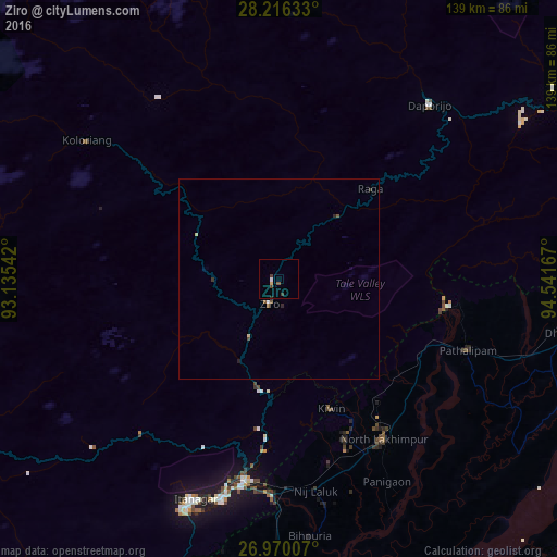
Analysis of Ziro night lights 2016
Square area 10x10 km:
 0.4%
0.4%90-99
0.4%80-89
0.6%70-79
0.2%60-69
0%50-59
0.79%40-49
0.79%30-39
1.59%20-29
0.4%10-19
0%0-9
94.84%Square area 50x50 km:
0.04%90-99
0.02%80-89
0.08%70-79
0.01%60-69
0%50-59
0.12%40-49
0.09%30-39
0.11%20-29
0.11%10-19
0.02%0-9
99.39%Clear (daylight) street map image can be seen on geolist.org.
Map coordinates:
28° 12' 58.8" North, 93° 8' 7.5" East
27° 35' 41.9" North, 93° 50' 18.7" East
26° 58' 12.3" North, 94° 32' 30" East
Some cities around Ziro sort by population:
• Jorhāt
99.9 km =62.1 mi,  158°
158°
• North Lakhimpur
47.8 km =29.7 mi,  146°
146°
• Itānagar
60.8 km =37.8 mi,  201°
201°
• Naharlagun
56.3 km =35 mi,  194°
194°
• Silapathar
87.3 km =54.2 mi,  90°
90°
• Dhemāji
74.5 km =46.3 mi,  99°
99°
• Bihpuriāgaon
64.7 km =40.2 mi,  173°
173°
• Gohpur
82.3 km =51.1 mi, 195°
1252668 (p: 13,893)
Sources (retrieved 2019-11-25):
» Earth at Night: Flat Maps 2012, 2016