Yellāpur night lights from space
Night Light of Yellāpur (Karnataka) from space (India) Src. Average luminocity for 10x10km area is 4.1632% and for 50x50km: 0.5689%.
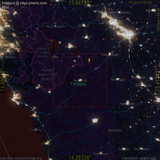
Analysis of Yellāpur night lights 2016
Square area 10x10 km:
 0%
0%90-99
0.83%80-89
0.83%70-79
2.48%60-69
0%50-59
0%40-49
0%30-39
0%20-29
0.41%10-19
1.24%0-9
94.21%Square area 50x50 km:
0.01%90-99
0.06%80-89
0.03%70-79
0.27%60-69
0.09%50-59
0.13%40-49
0.07%30-39
0.03%20-29
0.08%10-19
0.05%0-9
99.17%Clear (daylight) street map image can be seen on geolist.org.
Map coordinates:
15° 38' 30.8" North, 74° 0' 22.2" East
14° 57' 49.3" North, 74° 42' 33.4" East
14° 17' 0.1" North, 75° 24' 44.7" East
Some cities around Yellāpur sort by population:
• Sirsi
40.5 km =25.2 mi,  160°
160°
• Dandeli
35.1 km =21.8 mi,  343°
343°
• Hāngal
49.8 km =30.9 mi,  116°
116°
• Haliyal
40.9 km =25.4 mi,  7°
7°
• Mundgod
35.2 km =21.9 mi,  88°
88°
• Alnāvar
51.7 km =32.1 mi,  3°
3°
• Kalghatgi
37.2 km =23.1 mi,  49°
49°
• Ankola
55 km =34.2 mi,  232°
232°
1252744 (p: 19,343)
Sources (retrieved 2019-11-25):
» Earth at Night: Flat Maps 2012, 2016