Kalghatgi night lights from space
Night Light of Kalghatgi (Karnataka) from space (India) Src. Average luminocity for 10x10km area is 6.3368% and for 50x50km: 8.0791%.
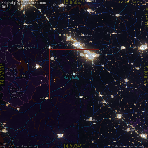
Analysis of Kalghatgi night lights 2016
Square area 10x10 km:
 0.21%
0.21%90-99
1.45%80-89
1.45%70-79
1.03%60-69
0%50-59
0%40-49
1.65%30-39
0.62%20-29
2.69%10-19
0.83%0-9
90.08%Square area 50x50 km:
1.58%90-99
1.74%80-89
0.82%70-79
0.48%60-69
0.94%50-59
0.9%40-49
1.55%30-39
1.35%20-29
2.34%10-19
3.31%0-9
85%Clear (daylight) street map image can be seen on geolist.org.
Map coordinates:
15° 51' 38.3" North, 74° 16' 4.3" East
15° 10' 59.3" North, 74° 58' 15.6" East
14° 30' 12.6" North, 75° 40' 26.8" East
Some cities around Kalghatgi sort by population:
• Hubli
25.3 km =15.7 mi,  43°
43°
• Dandeli
39.1 km =24.3 mi,  283°
283°
• Shiggaon
34.7 km =21.6 mi,  128°
128°
• Haliyal
28.1 km =17.5 mi,  305°
305°
• Yellāpur
37.2 km =23.1 mi,  229°
229°
• Kundgol
30.7 km =19.1 mi,  74°
74°
• Mundgod
24.6 km =15.3 mi,  163°
163°
• Alnāvar
36.7 km =22.8 mi,  317°
317°
1268434 (p: 15,428)
Sources (retrieved 2019-11-25):
» Earth at Night: Flat Maps 2012, 2016